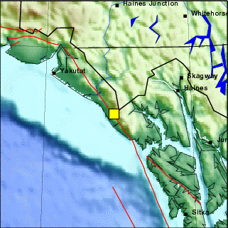
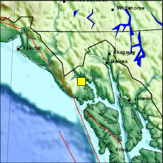
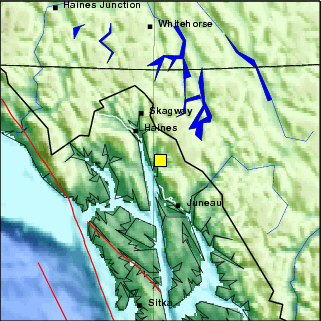
                     == PRELIMINARY EARTHQUAKE REPORT ==


Region:                           Southeastern Alaska
Geographic coordinates:           59.904N, 136.750W
Magnitude:                        5.1
Depth:                            10 km
Universal Time (UTC):             16 Sep 2017  23:38:03
Time near the Epicenter:          16 Sep 2017  16:38:03
Local standard time in your area: 16 Sep 2017  15:38:03

Location with respect to nearby cities:
55.8 km (34.6 mi) NW of Mosquito Lake, Alaska
130.3 km (80.8 mi) SW of Whitehorse, Canada
222.8 km (138.2 mi) NW of Juneau, Alaska
718.3 km (445.3 mi) ESE of Eagle River, Alaska
722.9 km (448.2 mi) ESE of Knik-Fairview, Alaska


ADDITIONAL EARTHQUAKE PARAMETERS
________________________________
event ID                     :  us 2000apcc

This is a computer-generated message and has not yet been reviewed by a
seismologist.
For subsequent updates, maps, and technical information, see:
http://earthquake.usgs.gov/earthquakes/eventpage/us2000apcc
or
https://earthquake.usgs.gov/

National Earthquake Information Center
U.S. Geological Survey


DISCLAIMER: https://earthquake.usgs.gov/ens/help.html?page=help#disclaimer
                     == PRELIMINARY EARTHQUAKE REPORT ==


Region:                           Southeastern Alaska
Geographic coordinates:           58.990N, 136.347W
Magnitude:                        4.0
Depth:                            3.8 km
Universal Time (UTC):             18 Aug 2017  04:44:36
Time near the Epicenter:          17 Aug 2017  20:44:36
Local standard time in your area: 17 Aug 2017  20:44:36

Location with respect to nearby cities:
51.0 km (31.6 mi) SSW of Covenant Life, Alaska
135.6 km (84.1 mi) WNW of Juneau, Alaska
205.5 km (127.4 mi) SSW of Whitehorse, Canada
637.9 km (395.5 mi) NW of Prince Rupert, Canada
686.6 km (425.7 mi) NW of Terrace, Canada


ADDITIONAL EARTHQUAKE PARAMETERS
________________________________
event ID                     :  ak 16550557

This is a computer-generated message and has not yet been reviewed by a
seismologist.
For subsequent updates, maps, and technical information, see:
http://earthquake.usgs.gov/earthquakes/eventpage/ak16550557
or
https://earthquake.usgs.gov/

Alaska Earthquake Information Center
Geophysical Institute, University of Alaska Fairbanks

http://www.aeic.alaska.edu
DISCLAIMER: https://earthquake.usgs.gov/ens/help.html?page=help#disclaimer
                     == PRELIMINARY EARTHQUAKE REPORT ==


Region:                            SOUTHEASTERN ALASKA
Geographic coordinates:           59.744N, 136.702W
Magnitude:                        6.3
Depth:                            10 km
Universal Time (UTC):              1 May 2017  14:18:16
Time near the Epicenter:           1 May 2017  06:18:16
Local standard time in your area:  1 May 2017  06:18:16

Location with respect to nearby cities:
  46 km (29 miles) NW (319 degrees) of Mosquito Lake, AK
  52 km (32 miles) NW (318 degrees) of Covenant Life, AK
  59 km (37 miles) NW (310 degrees) of Klukwan, AK
 732 km (455 miles) E (97 degrees) of Anchorage, AK


ADDITIONAL EARTHQUAKE PARAMETERS
________________________________
event ID                     :  us 10008mgu

This is a computer-generated message and has not yet been reviewed by a
seismologist.
For subsequent updates, maps, and technical information, see:
http://earthquake.usgs.gov/earthquakes/eventpage/us10008mgu
or
http://earthquake.usgs.gov/

National Earthquake Information Center
U.S. Geological Survey


DISCLAIMER: https://earthquake.usgs.gov/ens/help.html?page=help#disclaimer
                     == PRELIMINARY EARTHQUAKE REPORT ==

***This event supersedes event AK15853423.


Region:                            SOUTHEASTERN ALASKA
Geographic coordinates:           59.868N, 136.837W
Magnitude:                        5.2
Depth:                            4.6 km
Universal Time (UTC):              1 May 2017  12:49:19
Time near the Epicenter:           1 May 2017  04:49:19
Local standard time in your area:  1 May 2017  04:49:19

Location with respect to nearby cities:
  62 km (38 miles) NW (323 degrees) of Mosquito Lake, AK
  67 km (42 miles) NW (321 degrees) of Covenant Life, AK
  74 km (46 miles) NW (315 degrees) of Klukwan, AK
 721 km (448 miles) E (96 degrees) of Anchorage, AK


ADDITIONAL EARTHQUAKE PARAMETERS
________________________________
event ID                     :  us 10008mes

This is a computer-generated message and has not yet been reviewed by a
seismologist.
For subsequent updates, maps, and technical information, see:
http://earthquake.usgs.gov/earthquakes/eventpage/us10008mes
or
http://earthquake.usgs.gov/

National Earthquake Information Center
U.S. Geological Survey


DISCLAIMER: https://earthquake.usgs.gov/ens/help.html?page=help#disclaimer
                     == PRELIMINARY EARTHQUAKE REPORT ==


Region:                            SOUTHEASTERN ALASKA
Geographic coordinates:           59.844N, 136.695W
Magnitude:                        6.2
Depth:                            2 km
Universal Time (UTC):              1 May 2017  12:31:55
Time near the Epicenter:           1 May 2017  04:31:55
Local standard time in your area:  1 May 2017  04:31:55

Location with respect to nearby cities:
  55 km (34 miles) NNW (327 degrees) of Mosquito Lake, AK
  60 km (38 miles) NW (325 degrees) of Covenant Life, AK
  67 km (42 miles) NW (318 degrees) of Klukwan, AK
 729 km (453 miles) E (96 degrees) of Anchorage, AK


ADDITIONAL EARTHQUAKE PARAMETERS
________________________________
event ID                     :  us 10008mel

This is a computer-generated message and has not yet been reviewed by a
seismologist.
For subsequent updates, maps, and technical information, see:
http://earthquake.usgs.gov/earthquakes/eventpage/us10008mel
or
http://earthquake.usgs.gov/

National Earthquake Information Center
U.S. Geological Survey


DISCLAIMER: https://earthquake.usgs.gov/ens/help.html?page=help#disclaimer
                    == PRELIMINARY EARTHQUAKE REPORT ==


Region:                           SOUTHEASTERN ALASKA
Geographic coordinates:           58.670N, 134.775W
Magnitude:                        3.4
Depth:                            0.2 km
Universal Time (UTC):             30 Dec 2016  18:27:10
Time near the Epicenter:          30 Dec 2016  09:27:10
Local standard time in your area: 30 Dec 2016  09:27:10

Location with respect to nearby cities:
45 km (27 mi) NNW of Juneau, Alaska
228 km (141 mi) S of Whitehorse, Canada
556 km (344 mi) NNW of Prince Rupert, Canada
597 km (370 mi) NW of Terrace, Canada
876 km (543 mi) WNW of Fort St. John, Canada


ADDITIONAL EARTHQUAKE PARAMETERS
________________________________
event ID                     :  ak 14853757

This is a computer-generated message and has not yet been reviewed by a
seismologist.
For subsequent updates, maps, and technical information, see:
http://earthquake.usgs.gov/earthquakes/eventpage/ak14853757
or
http://earthquake.usgs.gov/

Alaska Earthquake Information Center
Geophysical Institute, University of Alaska Fairbanks

http://www.aeic.alaska.edu
DISCLAIMER: https://sslearthquake.usgs.gov/ens/help.html?page=help#disclaimer
                     == PRELIMINARY EARTHQUAKE REPORT ==


Region:                           SOUTHEASTERN ALASKA
Geographic coordinates:           57.868N, 133.067W
Magnitude:                        2.5
Depth:                            0 km
Universal Time (UTC):              5 Sep 2016  07:38:16
Time near the Epicenter:           4 Sep 2016  23:38:16
Local standard time in your area:  4 Sep 2016  23:38:16

Location with respect to nearby cities:
93 km (57 mi) ESE of Juneau, Alaska
336 km (208 mi) SSE of Whitehorse, Canada
430 km (266 mi) NNW of Prince Rupert, Canada
464 km (287 mi) NW of Terrace, Canada
761 km (471 mi) WNW of Fort St. John, Canada


ADDITIONAL EARTHQUAKE PARAMETERS
________________________________
event ID                     :  ak 13910141

This is a computer-generated message and has not yet been reviewed by a
seismologist.
For subsequent updates, maps, and technical information, see:
http://earthquake.usgs.gov/earthquakes/eventpage/ak13910141
or
http://earthquake.usgs.gov/

Alaska Earthquake Information Center
Geophysical Institute, University of Alaska Fairbanks

http://www.aeic.alaska.edu
DISCLAIMER: https://sslearthquake.usgs.gov/ens/help.html?page=help#disclaimer
                     == PRELIMINARY EARTHQUAKE REPORT ==


Region:                           SOUTHEASTERN ALASKA
Geographic coordinates:           58.976N, 137.258W
Magnitude:                        3.8
Depth:                            0 km
Universal Time (UTC):              5 Sep 2016  04:38:37
Time near the Epicenter:           4 Sep 2016  20:38:37
Local standard time in your area:  4 Sep 2016  20:38:37

Location with respect to nearby cities:
107 km (66 mi) WSW of Haines, Alaska
181 km (112 mi) WNW of Juneau, Alaska
229 km (141 mi) SSW of Whitehorse, Canada
670 km (415 mi) NW of Prince Rupert, Canada
724 km (448 mi) NW of Terrace, Canada


ADDITIONAL EARTHQUAKE PARAMETERS
________________________________
event ID                     :  ak 13909138

This is a computer-generated message and has not yet been reviewed by a
seismologist.
For subsequent updates, maps, and technical information, see:
http://earthquake.usgs.gov/earthquakes/eventpage/ak13909138
or
http://earthquake.usgs.gov/

Alaska Earthquake Information Center
Geophysical Institute, University of Alaska Fairbanks

http://www.aeic.alaska.edu
DISCLAIMER: https://sslearthquake.usgs.gov/ens/help.html?page=help#disclaimer
Magnitude 2.6 - 36 miles N of Juneau
August 21, 2016 17:26:40 AKDT
58.8282°N 134.3608°W Depth 3.1
miles
Nearest Communities
                     == PRELIMINARY EARTHQUAKE REPORT ==


Region:                           SOUTHEASTERN ALASKA
Geographic coordinates:           59.054N, 136.840W
Magnitude:                        3.7
Depth:                            1 km
Universal Time (UTC):              6 Mar 2015  08:48:44
Time near the Epicenter:           5 Mar 2015  23:48:44
Local standard time in your area:  5 Mar 2015  23:48:44

Location with respect to nearby cities:
82 km (51 mi) WSW of Haines, Alaska
163 km (101 mi) WNW of Juneau, Alaska
210 km (130 mi) SSW of Whitehorse, Canada
661 km (410 mi) NW of Prince Rupert, Canada
712 km (441 mi) NW of Terrace, Canada


ADDITIONAL EARTHQUAKE PARAMETERS
________________________________
event ID                     :  ak 11523317

This is a computer-generated message and has not yet been reviewed by a
seismologist.
For subsequent updates, maps, and technical information, see:
http://earthquake.usgs.gov/earthquakes/eventpage/ak11523317
or
http://earthquake.usgs.gov/

Alaska Earthquake Information Center
Geophysical Institute, University of Alaska Fairbanks

http://www.aeic.alaska.edu
DISCLAIMER: https://sslearthquake.usgs.gov/ens/help.html?page=help#disclaimer
                     == PRELIMINARY EARTHQUAKE REPORT ==


Region:                           SOUTHEASTERN ALASKA
Geographic coordinates:           58.350N, 136.911W
Magnitude:                        4.2
Depth:                            10 km
Universal Time (UTC):             18 Feb 2015  22:15:07
Time near the Epicenter:          18 Feb 2015  13:15:08
Local standard time in your area: 18 Feb 2015  13:15:07

Location with respect to nearby cities:
69 km (43 mi) W of Gustavus, Alaska
146 km (91 mi) W of Juneau, Alaska
283 km (175 mi) SSW of Whitehorse, Canada
606 km (376 mi) NW of Prince Rupert, Canada
666 km (413 mi) NW of Terrace, Canada


ADDITIONAL EARTHQUAKE PARAMETERS
________________________________
event ID                     :  us c000trbw

This is a computer-generated message and has not yet been reviewed by a
seismologist.
For subsequent updates, maps, and technical information, see:
http://earthquake.usgs.gov/earthquakes/eventpage/usc000trbw
or
http://earthquake.usgs.gov/


DISCLAIMER: https://sslearthquake.usgs.gov/ens/help.html?page=help#disclaimer
                     == PRELIMINARY EARTHQUAKE REPORT ==


Region:                           SOUTHEASTERN ALASKA
Geographic coordinates:           58.385N, 136.939W
Magnitude:                        3.6
Depth:                            9 km
Universal Time (UTC):             27 Dec 2014  21:15:49
Time near the Epicenter:          27 Dec 2014  12:15:49
Local standard time in your area: 27 Dec 2014  12:15:49

Location with respect to nearby cities:
70 km (43 mi) W of Gustavus, Alaska
147 km (91 mi) W of Juneau, Alaska
280 km (173 mi) SSW of Whitehorse, Canada
609 km (377 mi) NW of Prince Rupert, Canada
669 km (414 mi) NW of Terrace, Canada


ADDITIONAL EARTHQUAKE PARAMETERS
________________________________
event ID                     :  ak 11474305

This is a computer-generated message and has not yet been reviewed by a
seismologist.
For subsequent updates, maps, and technical information, see:
http://earthquake.usgs.gov/earthquakes/eventpage/ak11474305
or
http://earthquake.usgs.gov/

Alaska Earthquake Information Center
Geophysical Institute, University of Alaska Fairbanks

http://www.aeic.alaska.edu
DISCLAIMER: https://sslearthquake.usgs.gov/ens/help.html?page=help#disclaimer
                     == PRELIMINARY EARTHQUAKE REPORT ==


Region:                           SOUTHEASTERN ALASKA
Geographic coordinates:           59.178N, 136.277W
Magnitude:                        3.8
Depth:                            6 km
Universal Time (UTC):              5 Nov 2014  23:45:31
Time near the Epicenter:           5 Nov 2014  14:45:31
Local standard time in your area:  5 Nov 2014  14:45:31

Location with respect to nearby cities:
47 km (29 mi) W of Haines, Alaska
145 km (89 mi) NW of Juneau, Alaska
184 km (114 mi) SSW of Whitehorse, Canada
652 km (404 mi) NNW of Prince Rupert, Canada
698 km (432 mi) NW of Terrace, Canada


ADDITIONAL EARTHQUAKE PARAMETERS
________________________________
event ID                     :  ak 11434676

This is a computer-generated message and has not yet been reviewed by a
seismologist.
For subsequent updates, maps, and technical information, see:
http://earthquake.usgs.gov/earthquakes/eventpage/ak11434676
or
http://earthquake.usgs.gov/

Alaska Earthquake Information Center
Geophysical Institute, University of Alaska Fairbanks

http://www.aeic.alaska.edu
DISCLAIMER: https://sslearthquake.usgs.gov/ens/help.html?page=help#disclaimer
-----------------------------------------------------------------------------
000
SEAK71 PAAQ 052347
EQIAKX

TSUNAMI SEISMIC INFORMATION STATEMENT
NWS NATIONAL TSUNAMI WARNING CENTER PALMER AK
247 PM AKST WED NOV 5 2014

...THIS IS A TSUNAMI INFORMATION STATEMENT...


EVALUATION
----------
 * AN EARTHQUAKE HAS OCCURRED - THERE IS NO TSUNAMI DANGER.


PRELIMINARY EARTHQUAKE PARAMETERS
---------------------------------
 * MAGNITUDE      4.1
 * ORIGIN TIME    1446 AKST NOV 05 2014
                  1546  PST NOV 05 2014
                  2346  UTC NOV 05 2014
 * COORDINATES    59.2 NORTH 136.2 WEST
 * DEPTH          4 MILES
 * LOCATION       30 MILES W OF HAINES ALASKA
                  90 MILES NW OF JUNEAU ALASKA


NEXT UPDATE AND ADDITIONAL INFORMATION
--------------------------------------
 * THIS WILL BE THE ONLY U.S. NATIONAL TSUNAMI WARNING CENTER
   MESSAGE ISSUED FOR THIS EVENT.

 * THE EARTHQUAKE PARAMETERS ARE BASED ON PRELIMINARY INFORMATION.

 * FURTHER INFORMATION WILL BE ISSUED BY THE UNITED STATES
   GEOLOGICAL SURVEY - EARTHQUAKE.USGS.GOV - OR THE APPROPRIATE
   REGIONAL SEISMIC NETWORK.

$$
                     == PRELIMINARY EARTHQUAKE REPORT ==

***1200: This event supersedes event AK11434269.


Region:                           SOUTHEASTERN ALASKA
Geographic coordinates:           59.170N, 136.350W
Magnitude:                        4.6
Depth:                            2 km
Universal Time (UTC):              5 Nov 2014  16:03:51
Time near the Epicenter:           5 Nov 2014  07:03:51
Local standard time in your area:  5 Nov 2014  07:03:51

Location with respect to nearby cities:
52 km (32 mi) W of Haines, Alaska
147 km (91 mi) NW of Juneau, Alaska
186 km (115 mi) SSW of Whitehorse, Canada
653 km (404 mi) NNW of Prince Rupert, Canada
700 km (434 mi) NW of Terrace, Canada


ADDITIONAL EARTHQUAKE PARAMETERS
________________________________
event ID                     :  us c000suk4

This is a computer-generated message and has not yet been reviewed by a
seismologist.
For subsequent updates, maps, and technical information, see:
http://earthquake.usgs.gov/earthquakes/eventpage/usc000suk4
or
http://earthquake.usgs.gov/

National Earthquake Information Center
U.S. Geological Survey
http://earthquake.usgs.gov/regional/neic/


DISCLAIMER: https://sslearthquake.usgs.gov/ens/help.html?page=help#disclaimer
-----------------------------------------------------------------------------
000
SEAK71 PAAQ 051605
EQIAKX

TSUNAMI SEISMIC INFORMATION STATEMENT
NWS NATIONAL TSUNAMI WARNING CENTER PALMER AK
705 AM AKST WED NOV 5 2014

...THIS IS A TSUNAMI INFORMATION STATEMENT...


EVALUATION
----------
 * AN EARTHQUAKE HAS OCCURRED - THERE IS NO TSUNAMI DANGER.


PRELIMINARY EARTHQUAKE PARAMETERS
---------------------------------
 * MAGNITUDE      4.8
 * ORIGIN TIME    0704 AKST NOV 05 2014
                  0804  PST NOV 05 2014
                  1604  UTC NOV 05 2014
 * COORDINATES    59.2 NORTH 136.2 WEST
 * DEPTH          6 MILES
 * LOCATION       30 MILES W OF HAINES ALASKA
                  90 MILES NW OF JUNEAU ALASKA


NEXT UPDATE AND ADDITIONAL INFORMATION
--------------------------------------
 * THIS WILL BE THE ONLY U.S. NATIONAL TSUNAMI WARNING CENTER
   MESSAGE ISSUED FOR THIS EVENT.

 * THE EARTHQUAKE PARAMETERS ARE BASED ON PRELIMINARY INFORMATION.

 * FURTHER INFORMATION WILL BE ISSUED BY THE UNITED STATES
   GEOLOGICAL SURVEY - EARTHQUAKE.USGS.GOV - OR THE APPROPRIATE
   REGIONAL SEISMIC NETWORK.

$$
                     == PRELIMINARY EARTHQUAKE REPORT ==


Region:                           SOUTHEASTERN ALASKA
Geographic coordinates:           58.255N, 137.083W
Magnitude:                        4.0 ml
Depth:                            10 km
Universal Time (UTC):             26 Jul 2014  20:53:09
Time near the Epicenter:          26 Jul 2014  12:53:10
Local standard time in your area: 26 Jul 2014  12:53:09

Location with respect to nearby cities:
80 km (49 mi) WSW of Gustavus, Alaska
156 km (96 mi) W of Juneau, Alaska
297 km (184 mi) SSW of Whitehorse, Canada
605 km (375 mi) NW of Prince Rupert, Canada
668 km (414 mi) NW of Terrace, Canada


ADDITIONAL EARTHQUAKE PARAMETERS
________________________________
event ID                     :  us b000rxm6

This is a computer-generated message and has not yet been reviewed by a
seismologist.
For subsequent updates, maps, and technical information, see:
http://earthquake.usgs.gov/earthquakes/eventpage/usb000rxm6
or
http://earthquake.usgs.gov/

National Earthquake Information Center
U.S. Geological Survey
http://earthquake.usgs.gov/regional/neic/


DISCLAIMER: https://sslearthquake.usgs.gov/ens/help.html?page=help#disclaimer
                     == PRELIMINARY EARTHQUAKE REPORT ==


Region:                           SOUTHEASTERN ALASKA
Geographic coordinates:           58.278N, 137.038W
Magnitude:                        3.8 ml
Depth:                            10 km
Universal Time (UTC):             25 Jul 2014  16:00:40
Time near the Epicenter:          25 Jul 2014  08:00:40
Local standard time in your area: 25 Jul 2014  08:00:40

Location with respect to nearby cities:
77 km (47 mi) W of Gustavus, Alaska
153 km (94 - 95 mi) W of Juneau, Alaska
293 km (181 mi) SSW of Whitehorse, Canada
605 km (375 mi) NW of Prince Rupert, Canada
667 km (413 mi) NW of Terrace, Canada


ADDITIONAL EARTHQUAKE PARAMETERS
________________________________
event ID                     :  us b000rx93

This is a computer-generated message and has not yet been reviewed by a
seismologist.
For subsequent updates, maps, and technical information, see:
http://earthquake.usgs.gov/earthquakes/eventpage/usb000rx93
or
http://earthquake.usgs.gov/

National Earthquake Information Center
U.S. Geological Survey
http://earthquake.usgs.gov/regional/neic/


DISCLAIMER: https://sslearthquake.usgs.gov/ens/help.html?page=help#disclaimer
                     == PRELIMINARY EARTHQUAKE REPORT ==


Region:                           SOUTHEASTERN ALASKA
Geographic coordinates:           58.516N, 136.730W
Magnitude:                        3.7 ml
Depth:                            10 km
Universal Time (UTC):             25 Jul 2014  15:12:53
Time near the Epicenter:          25 Jul 2014  07:12:53
Local standard time in your area: 25 Jul 2014  07:12:53

Location with respect to nearby cities:
59 km (36 mi) WNW of Gustavus, Alaska
137 km (84 - 85 mi) W of Juneau, Alaska
262 km (162 mi) SSW of Whitehorse, Canada
612 km (379 mi) NW of Prince Rupert, Canada
668 km (414 mi) NW of Terrace, Canada


ADDITIONAL EARTHQUAKE PARAMETERS
________________________________
event ID                     :  us b000rx7j

This is a computer-generated message and has not yet been reviewed by a
seismologist.
For subsequent updates, maps, and technical information, see:
http://earthquake.usgs.gov/earthquakes/eventpage/usb000rx7j
or
http://earthquake.usgs.gov/

National Earthquake Information Center
U.S. Geological Survey
http://earthquake.usgs.gov/regional/neic/


DISCLAIMER: https://sslearthquake.usgs.gov/ens/help.html?page=help#disclaimer
Outage Notification
Friday, July 25, 2014
We are currently experiencing a wireless and Internet service outage affecting customers in Southeast Alaska. The outage was caused by a 5.9 magnitude earthquake 97 miles west of Juneau and started at around 3:00 a.m.
Restoring service quickly is our highest priority.
Our Integrated Network Management Center in Anchorage has contacted emergency services in the area.
We will provide updates as they become available. We are committed to providing the highest level of customer service to Alaskans. We appreciate our customers understanding and patience and thank our people for their work in this recovery effort.
Anand Vadapalli
President and CEO
Alaska Communications
                     == PRELIMINARY EARTHQUAKE REPORT ==


Region:                           SOUTHEASTERN ALASKA
Geographic coordinates:           58.202N, 136.913W
Magnitude:                        3.8 ml
Depth:                            10 km
Universal Time (UTC):             25 Jul 2014  13:06:30
Time near the Epicenter:          25 Jul 2014  05:06:31
Local standard time in your area: 25 Jul 2014  05:06:30

Location with respect to nearby cities:
72 km (44 mi) WSW of Gustavus, Alaska
146 km (90 - 91 mi) W of Juneau, Alaska
299 km (185 mi) SSW of Whitehorse, Canada
594 km (368 mi) NW of Prince Rupert, Canada
656 km (406 mi) NW of Terrace, Canada


ADDITIONAL EARTHQUAKE PARAMETERS
________________________________
event ID                     :  us b000rx72

This is a computer-generated message and has not yet been reviewed by a
seismologist.
For subsequent updates, maps, and technical information, see:
http://earthquake.usgs.gov/earthquakes/eventpage/usb000rx72
or
http://earthquake.usgs.gov/

National Earthquake Information Center
U.S. Geological Survey
http://earthquake.usgs.gov/regional/neic/


DISCLAIMER: https://sslearthquake.usgs.gov/ens/help.html?page=help#disclaimer
                     == PRELIMINARY EARTHQUAKE REPORT ==


Region:                           SOUTHEASTERN ALASKA
Geographic coordinates:           58.267N, 137.025W
Magnitude:                        3.9 ml
Depth:                            10 km
Universal Time (UTC):             25 Jul 2014  11:53:19
Time near the Epicenter:          25 Jul 2014  03:53:20
Local standard time in your area: 25 Jul 2014  03:53:19

Location with respect to nearby cities:
77 km (47 mi) WSW of Gustavus, Alaska
152 km (94 mi) W of Juneau, Alaska
294 km (182 mi) SSW of Whitehorse, Canada
604 km (374 mi) NW of Prince Rupert, Canada
666 km (412 mi) NW of Terrace, Canada


ADDITIONAL EARTHQUAKE PARAMETERS
________________________________
event ID                     :  us b000rx6l

This is a computer-generated message and has not yet been reviewed by a
seismologist.
For subsequent updates, maps, and technical information, see:
http://earthquake.usgs.gov/earthquakes/eventpage/usb000rx6l
or
http://earthquake.usgs.gov/

National Earthquake Information Center
U.S. Geological Survey
http://earthquake.usgs.gov/regional/neic/


DISCLAIMER: https://sslearthquake.usgs.gov/ens/help.html?page=help#disclaimer
                     == PRELIMINARY EARTHQUAKE REPORT ==


Region:                           SOUTHEASTERN ALASKA
Geographic coordinates:           58.298N, 137.000W
Magnitude:                        4.0 mb
Depth:                            10 km
Universal Time (UTC):             25 Jul 2014  11:33:55
Time near the Epicenter:          25 Jul 2014  03:33:56
Local standard time in your area: 25 Jul 2014  03:33:55

Location with respect to nearby cities:
75 km (46 mi) W of Gustavus, Alaska
151 km (94 mi) W of Juneau, Alaska
290 km (179 mi) SSW of Whitehorse, Canada
605 km (375 mi) NW of Prince Rupert, Canada
667 km (413 mi) NW of Terrace, Canada


ADDITIONAL EARTHQUAKE PARAMETERS
________________________________
event ID                     :  us b000rx69

This is a computer-generated message and has not yet been reviewed by a
seismologist.
For subsequent updates, maps, and technical information, see:
http://earthquake.usgs.gov/earthquakes/eventpage/usb000rx69
or
http://earthquake.usgs.gov/

National Earthquake Information Center
U.S. Geological Survey
http://earthquake.usgs.gov/regional/neic/


DISCLAIMER: https://sslearthquake.usgs.gov/ens/help.html?page=help#disclaimer
                     == PRELIMINARY EARTHQUAKE REPORT ==


Region:                           SOUTHEASTERN ALASKA
Geographic coordinates:           58.480N, 137.055W
Magnitude:                        4.4 mb
Depth:                            10 km
Universal Time (UTC):             25 Jul 2014  11:19:36
Time near the Epicenter:          25 Jul 2014  03:19:36
Local standard time in your area: 25 Jul 2014  03:19:36

Location with respect to nearby cities:
77 km (47 mi) W of Gustavus, Alaska
155 km (96 mi) W of Juneau, Alaska
273 km (169 mi) SSW of Whitehorse, Canada
622 km (385 mi) NW of Prince Rupert, Canada
681 km (422 mi) NW of Terrace, Canada


ADDITIONAL EARTHQUAKE PARAMETERS
________________________________
event ID                     :  us b000rx63

This is a computer-generated message and has not yet been reviewed by a
seismologist.
For subsequent updates, maps, and technical information, see:
http://earthquake.usgs.gov/earthquakes/eventpage/usb000rx63
or
http://earthquake.usgs.gov/

National Earthquake Information Center
U.S. Geological Survey
http://earthquake.usgs.gov/regional/neic/


DISCLAIMER: https://sslearthquake.usgs.gov/ens/help.html?page=help#disclaimer
                     == PRELIMINARY EARTHQUAKE REPORT ==


Region:                           SOUTHEASTERN ALASKA
Geographic coordinates:           58.283N, 137.120W
Magnitude:                        4.5 mb
Depth:                            10 km
Universal Time (UTC):             25 Jul 2014  11:08:39
Time near the Epicenter:          25 Jul 2014  03:08:39
Local standard time in your area: 25 Jul 2014  03:08:39

Location with respect to nearby cities:
82 km (50 mi) W of Gustavus, Alaska
158 km (98 mi) W of Juneau, Alaska
295 km (182 mi) SSW of Whitehorse, Canada
609 km (377 mi) NW of Prince Rupert, Canada
671 km (416 mi) NW of Terrace, Canada


ADDITIONAL EARTHQUAKE PARAMETERS
________________________________
event ID                     :  us b000rx5r

This is a computer-generated message and has not yet been reviewed by a
seismologist.
For subsequent updates, maps, and technical information, see:
http://earthquake.usgs.gov/earthquakes/eventpage/usb000rx5r
or
http://earthquake.usgs.gov/

National Earthquake Information Center
U.S. Geological Survey
http://earthquake.usgs.gov/regional/neic/


DISCLAIMER: https://sslearthquake.usgs.gov/ens/help.html?page=help#disclaimer
000
SEAK71 PAAQ 251057
EQIAKX

TSUNAMI SEISMIC INFORMATION STATEMENT
NWS NATIONAL TSUNAMI WARNING CENTER PALMER AK
257 AM AKDT FRI JUL 25 2014

...THIS IS A TSUNAMI INFORMATION STATEMENT...


EVALUATION
----------
 * AN EARTHQUAKE HAS OCCURRED - A TSUNAMI IS NOT EXPECTED.


PRELIMINARY EARTHQUAKE PARAMETERS
---------------------------------
 * MAGNITUDE      5.9
 * ORIGIN TIME    0254 AKDT JUL 25 2014
                  0354  PDT JUL 25 2014
                  1054  UTC JUL 25 2014
 * COORDINATES    58.3 NORTH 137.2 WEST
 * DEPTH          3 MILES
 * LOCATION       90 MILES SW OF HAINES ALASKA
                  100 MILES W OF JUNEAU ALASKA


NEXT UPDATE AND ADDITIONAL INFORMATION
--------------------------------------
 * THIS WILL BE THE ONLY U.S. NATIONAL TSUNAMI WARNING CENTER
   MESSAGE ISSUED FOR THIS EVENT.

 * THE EARTHQUAKE PARAMETERS ARE BASED ON PRELIMINARY INFORMATION.

 * FURTHER INFORMATION WILL BE ISSUED BY THE UNITED STATES
   GEOLOGICAL SURVEY - EARTHQUAKE.USGS.GOV - OR THE APPROPRIATE
   REGIONAL SEISMIC NETWORK.

$$
                     == PRELIMINARY EARTHQUAKE REPORT ==


Region:                           SOUTHEASTERN ALASKA
Geographic coordinates:           58.358N, 137.130W
Magnitude:                        5.9 ml
Depth:                            10 km
Universal Time (UTC):             25 Jul 2014  10:54:49
Time near the Epicenter:          25 Jul 2014  02:54:49
Local standard time in your area: 25 Jul 2014  02:54:49

Location with respect to nearby cities:
81 km (50 mi) W of Gustavus, Alaska
158 km (98 mi) W of Juneau, Alaska
287 km (177 mi) SSW of Whitehorse, Canada
615 km (381 mi) NW of Prince Rupert, Canada
677 km (419 mi) NW of Terrace, Canada


ADDITIONAL EARTHQUAKE PARAMETERS
________________________________
event ID                     :  us b000rx5i

This is a computer-generated message and has not yet been reviewed by a
seismologist.
For subsequent updates, maps, and technical information, see:
http://earthquake.usgs.gov/earthquakes/eventpage/usb000rx5i
or
http://earthquake.usgs.gov/

National Earthquake Information Center
U.S. Geological Survey
http://earthquake.usgs.gov/regional/neic/


DISCLAIMER: https://sslearthquake.usgs.gov/ens/help.html?page=help#disclaimer
                     == PRELIMINARY EARTHQUAKE REPORT ==


Region:                           SOUTHEASTERN ALASKA
Geographic coordinates:           58.278N, 137.076W
Magnitude:                        4.7 mb
Depth:                            10 km
Universal Time (UTC):             25 Jul 2014  10:54:06
Time near the Epicenter:          25 Jul 2014  02:54:06
Local standard time in your area: 25 Jul 2014  02:54:06

Location with respect to nearby cities:
79 km (48 mi) W of Gustavus, Alaska
155 km (96 mi) W of Juneau, Alaska
294 km (182 mi) SSW of Whitehorse, Canada
607 km (376 mi) NW of Prince Rupert, Canada
669 km (414 mi) NW of Terrace, Canada


ADDITIONAL EARTHQUAKE PARAMETERS
________________________________
event ID                     :  us b000rx5g

This is a computer-generated message and has not yet been reviewed by a
seismologist.
For subsequent updates, maps, and technical information, see:
http://earthquake.usgs.gov/earthquakes/eventpage/usb000rx5g
or
http://earthquake.usgs.gov/

National Earthquake Information Center
U.S. Geological Survey
http://earthquake.usgs.gov/regional/neic/


DISCLAIMER: https://sslearthquake.usgs.gov/ens/help.html?page=help#disclaimer
| Local Date: | Wednesday June 4th, 2014 |
| Local Time: | 03:58 AM AKDT |
| Universal Time: | 06/04/2014 11:58:56.169 UTC |
| Magnitude: | 5.84 ML |
| Latitude: | 58.9939 |
| Longitude: | -136.7302 |
| Depth: | 14 miles (22 km) |
| Author: | AK:dutylap |
| 41 miles (65 km) SW of Klukwan |
| 49 miles (78 km) WSW of Haines |
| 54 miles (87 km) NW of Gustavus |
| 58 miles (92 km) NNW of Elfin Cove |
| 60 miles (96 km) WSW of Skagway |
| 74 miles (119 km) NNW of Pelican |
| 77 miles (124 km) NW of Hoonah |
| 96 miles (154 km) WNW of Juneau |
| 98 miles (157 km) WNW of Douglas |
| 101 miles (162 km) NNW of Tenakee Springs |
| 113 miles (181 km) ESE of Yakutat |
| 122 miles (195 km) SSW of Whitehorse |
| 364 miles (583 km) ESE of Valdez |
| 481 miles (769 km) ESE of Anchorage |
| 541 miles (865 km) SE of Fairbanks |
                     == PRELIMINARY EARTHQUAKE REPORT ==


Region:                           SOUTHEASTERN ALASKA
Geographic coordinates:           59.000N, 136.656W
Magnitude:                        5.7
Depth:                            10 km
Universal Time (UTC):              4 Jun 2014  11:58:58
Time near the Epicenter:           4 Jun 2014  03:58:58
Local standard time in your area:  4 Jun 2014  03:58:58

Location with respect to nearby cities:
73 km (45 mi) WSW of Haines, Alaska
151 km (93 mi) WNW of Juneau, Alaska
211 km (130 mi) SSW of Whitehorse, Canada
649 km (402 mi) NW of Prince Rupert, Canada
700 km (434 mi) NW of Terrace, Canada


ADDITIONAL EARTHQUAKE PARAMETERS
________________________________
event ID                     :  us c000rauc

This is a computer-generated message and has not yet been reviewed by a
seismologist.
For subsequent updates, maps, and technical information, see:
http://earthquake.usgs.gov/earthquakes/eventpage/usc000rauc
or
http://earthquake.usgs.gov/

National Earthquake Information Center
U.S. Geological Survey
http://earthquake.usgs.gov/regional/neic/


DISCLAIMER: https://sslearthquake.usgs.gov/ens/help.html?page=help#disclaimer
000
SEAK71 PAAQ 041201
EQIAKX

TSUNAMI SEISMIC INFORMATION STATEMENT
NWS NATIONAL TSUNAMI WARNING CENTER PALMER AK
401 AM AKDT WED JUN 4 2014

...THIS IS A TSUNAMI INFORMATION STATEMENT...


EVALUATION
----------
 * AN EARTHQUAKE HAS OCCURRED - A TSUNAMI IS NOT EXPECTED.


PRELIMINARY EARTHQUAKE PARAMETERS
---------------------------------
 * MAGNITUDE      5.8
 * ORIGIN TIME    0359 AKDT JUN 04 2014
                  0459  PDT JUN 04 2014
                  1159  UTC JUN 04 2014
 * COORDINATES    59.0 NORTH 136.7 WEST
 * DEPTH          7 MILES
 * LOCATION       50 MILES SW OF HAINES ALASKA
                  95 MILES NW OF JUNEAU ALASKA


NEXT UPDATE AND ADDITIONAL INFORMATION
--------------------------------------
 * THIS WILL BE THE ONLY U.S. NATIONAL TSUNAMI WARNING CENTER
   MESSAGE ISSUED FOR THIS EVENT.

 * THE EARTHQUAKE PARAMETERS ARE BASED ON PRELIMINARY INFORMATION.

 * FURTHER INFORMATION WILL BE ISSUED BY THE UNITED STATES
   GEOLOGICAL SURVEY - EARTHQUAKE.USGS.GOV - OR THE APPROPRIATE
   REGIONAL SEISMIC NETWORK.
NWS-WCATWC Tsunami Cancellation Message (Last Bulletin)

WEAK51 PAAQ 051058
TSUAK1

BULLETIN
PUBLIC TSUNAMI MESSAGE NUMBER 4
NWS WEST COAST/ALASKA TSUNAMI WARNING CENTER PALMER AK
158 AM AKST SAT JAN 5 2013

...THE TSUNAMI WARNING IS CANCELLED...


CANCELLATIONS
-------------
 * THE TSUNAMI WARNING IS CANCELED FOR THE COASTAL AREAS OF
   BRITISH COLUMBIA AND ALASKA FROM THE NORTH TIP OF VANCOUVER
   ISLAND BRITISH COLUMBIA TO CAPE FAIRWEATHER ALASKA/LOCATED
   80 MILES SE OF YAKUTAT/


IMPACTS - UPDATED
-----------------
 * A TSUNAMI WAS GENERATED DURING THIS EVENT BUT NO LONGER
   POSES A THREAT.

 * SOME AREAS MAY CONTINUE TO SEE SMALL SEA LEVEL CHANGES.

 * THE DETERMINATION TO RE-OCCUPY HAZARD ZONES MUST BE MADE BY
   LOCAL OFFICIALS.


RECOMMENDED ACTIONS - UPDATED
-----------------------------
 * DO NOT RE-OCCUPY HAZARD ZONES UNTIL LOCAL EMERGENCY OFFICIALS
   INDICATE IT IS SAFE TO DO SO.


OBSERVATIONS OF TSUNAMI ACTIVITY - UPDATED
------------------------------------------
                                  TIME             OBSERVED MAX
 SITE                         OF MEASUREMENT       TSUNAMI HEIGHT
 ---------------------------- ---------------      --------------
 PORT ALEXANDER  AK           1026 UTC  01-05        00.5FT
 SITKA  AK                    1041 UTC  01-05        00.3FT

 HEIGHT - OBSERVED MAX TSUNAMI HEIGHT IS THE WATER LEVEL ABOVE THE
          TIDE LEVEL AT THE TIME OF MEASUREMENT.

 DEEP OCEAN PRESSURE SENSORS DID NOT RECORD A TSUNAMI.


NEXT UPDATE AND ADDITIONAL INFORMATION
--------------------------------------
 * THIS WILL BE THE LAST WEST COAST/ALASKA TSUNAMI WARNING CENTER
   BULLETIN ISSUED FOR THIS EVENT.

 * REFER TO THE INTERNET SITE WCATWC.ARH.NOAA.GOV FOR MORE
   INFORMATION.

 * PACIFIC COASTAL REGIONS OUTSIDE CALIFORNIA... OREGON...
   WASHINGTON... BRITISH COLUMBIA AND ALASKA SHOULD REFER TO THE
   PACIFIC TSUNAMI WARNING CENTER MESSAGES FOR INFORMATION AT
   PTWC.WEATHER.GOV.
NWS-WCATWC Tsunami Warning

WEAK51 PAAQ 051017
TSUAK1

BULLETIN
PUBLIC TSUNAMI MESSAGE NUMBER 3
NWS WEST COAST/ALASKA TSUNAMI WARNING CENTER PALMER AK
117 AM AKST SAT JAN 5 2013

THE MAGNITUDE HAS BEEN UPDATED TO 7.5 AND A SMALL TSUNAMI
HAS BEEN OBSERVED AT PORT ALEXANDER, ALASKA.

...THE TSUNAMI WARNING REMAINS IN EFFECT...


WARNINGS/ADVISORIES/WATCHES - UPDATED
-------------------------------------
TSUNAMI WARNING IN EFFECT FOR...

 * THE COASTAL AREAS OF BRITISH COLUMBIA AND ALASKA FROM THE
   NORTH TIP OF VANCOUVER ISLAND BRITISH COLUMBIA TO CAPE
   FAIRWEATHER ALASKA/LOCATED 80 MILES SE OF YAKUTAT/


CANCELLATIONS
-------------
 * THE TSUNAMI ADVISORY IS CANCELED FOR THE COASTAL AREAS OF
   BRITISH COLUMBIA FROM THE WASHINGTON-BRITISH COLUMBIA
   BORDER TO THE NORTH TIP OF VANCOUVER ISLAND BRITISH
   COLUMBIA

 * THE TSUNAMI WARNING IS CANCELED FOR THE COASTAL AREAS OF
   ALASKA FROM CAPE FAIRWEATHER ALASKA/LOCATED 80 MILES SE OF
   YAKUTAT/ TO CAPE SUCKLING ALASKA/LOCATED 75 MILES SE OF
   CORDOVA/

 * THE TSUNAMI ADVISORY IS CANCELED FOR THE COASTAL AREAS OF
   ALASKA FROM CAPE SUCKLING ALASKA/LOCATED 75 MILES SE OF
   CORDOVA/ TO KENNEDY ENTRANCE ALASKA/LOCATED 40 MILES SW OF
   HOMER/


IMPACTS FOR TSUNAMI WARNING AREAS
---------------------------------
 * A TSUNAMI WITH SIGNIFICANT WIDESPREAD INUNDATION OF LAND IS
   EXPECTED.

 * WIDESPREAD DANGEROUS COASTAL FLOODING ACCOMPANIED BY POWERFUL
   CURRENTS IS POSSIBLE AND MAY CONTINUE FOR MANY HOURS AFTER
   TSUNAMI ARRIVAL.

 * THE FIRST WAVE MAY NOT BE THE LARGEST.


RECOMMENDED ACTIONS - UPDATED
-----------------------------
 * IF YOU ARE IN A WARNING AREA - MOVE INLAND TO HIGHER GROUND.

 * BE ALERT TO INSTRUCTIONS FROM YOUR LOCAL EMERGENCY OFFICIALS.

 * DO NOT GO TO THE COAST TO OBSERVE THE TSUNAMI.

 * DO NOT RETURN TO THE COAST UNTIL LOCAL EMERGENCY OFFICIALS
   INDICATE IT IS SAFE TO DO SO.


FORECASTS AND/OR OBSERVATIONS OF TSUNAMI ACTIVITY
-------------------------------------------------
                 FORECAST         FORECAST  FORECAST       OBSERVED
                 START OF         TSUNAMI   MAX TSUNAMI    TSUNAMI
SITE             OF TSUNAMI       DURATION  HEIGHT         HEIGHT
----             ----------       --------  -------------  -------

 * BRITISH COLUMBIA
LANGARA          0129  PST JAN  5

 * ALASKA
SITKA            0043 AKST JAN  5
ELFIN COVE       0055 AKST JAN  5
CRAIG            0115 AKST JAN  5

FORECAST MAX TSUNAMI HEIGHT IS THE HIGHEST EXPECTED WATER LEVEL
ABOVE THE TIDE.

FORECAST TSUNAMI DURATION IS THE APPROXIMATE LENGTH OF TIME WHICH
THE TSUNAMI MAY PRODUCE DANGEROUS CURRENTS AND WAVE ACTIVITY.

OBSERVED TSUNAMI HEIGHT IS THE HIGHEST WATER LEVEL ABOVE THE
TIDE LEVEL AT THE TIME OF MEASUREMENT.


ADDITIONAL OBSERVATIONS OF TSUNAMI ACTIVITY - UPDATED
-----------------------------------------------------
                                  TIME             OBSERVED MAX
 SITE                         OF MEASUREMENT       TSUNAMI HEIGHT
 ---------------------------- ---------------      --------------
 PORT ALEXANDER  AK           1007 UTC  01-05        00.5FT

 HEIGHT - OBSERVED MAX TSUNAMI HEIGHT IS THE WATER LEVEL ABOVE THE
          TIDE LEVEL AT THE TIME OF MEASUREMENT.


PRELIMINARY EARTHQUAKE PARAMETERS
---------------------------------
 * MAGNITUDE      7.5
 * ORIGIN TIME    2358 AKST JAN 04 2013
                  0058  PST JAN 05 2013
                  0858  UTC JAN 05 2013
 * COORDINATES    55.3 NORTH 134.9 WEST
 * DEPTH          3 MILES
 * LOCATION       95 MILES NW OF DIXON ENTRANCE ALASKA
                  210 MILES S OF JUNEAU ALASKA


NEXT UPDATE AND ADDITIONAL INFORMATION
--------------------------------------
 * THIS MESSAGE WILL BE UPDATED IN 45 MINUTES.

 * REFER TO THE INTERNET SITE WCATWC.ARH.NOAA.GOV FOR MORE
   INFORMATION.

 * PACIFIC COASTAL RESIDENTS OUTSIDE CALIFORNIA... OREGON...
   WASHINGTON... BRITISH COLUMBIA AND ALASKA SHOULD REFER TO THE
   PACIFIC TSUNAMI WARNING CENTER MESSAGES FOR INFORMATION ON THIS
   EVENT AT PTWC.WEATHER.GOV.
0030: NWS-WCATWC Tsunami Warning/Advisory

WEAK51 PAAQ 050930
TSUAK1

BULLETIN
PUBLIC TSUNAMI MESSAGE NUMBER 2
NWS WEST COAST/ALASKA TSUNAMI WARNING CENTER PALMER AK
1230 AM AKST SAT JAN 5 2013

THE MAGNITUDE HAS BEEN MODIFIED TO 7.6.  THE WARNING AND
ADVISORY REGIONS REMAIN THE SAME.

...THE TSUNAMI WARNING REMAINS IN EFFECT...


...THE TSUNAMI ADVISORY REMAINS IN EFFECT...


WARNINGS/ADVISORIES/WATCHES
---------------------------
TSUNAMI WARNING IN EFFECT FOR...

 * THE COASTAL AREAS OF BRITISH COLUMBIA AND ALASKA FROM THE
   NORTH TIP OF VANCOUVER ISLAND BRITISH COLUMBIA TO CAPE
   SUCKLING ALASKA/LOCATED 75 MILES SE OF CORDOVA/


TSUNAMI ADVISORY IN EFFECT FOR...

 * THE COASTAL AREAS OF BRITISH COLUMBIA FROM THE
   WASHINGTON-BRITISH COLUMBIA BORDER TO THE NORTH TIP OF
   VANCOUVER ISLAND BRITISH COLUMBIA

 * THE COASTAL AREAS OF ALASKA FROM CAPE SUCKLING
   ALASKA/LOCATED 75 MILES SE OF CORDOVA/ TO KENNEDY ENTRANCE
   ALASKA/LOCATED 40 MILES SW OF HOMER/


IMPACTS FOR TSUNAMI WARNING AREAS
---------------------------------
 * A TSUNAMI WITH SIGNIFICANT WIDESPREAD INUNDATION OF LAND IS
   EXPECTED.

 * WIDESPREAD DANGEROUS COASTAL FLOODING ACCOMPANIED BY POWERFUL
   CURRENTS IS POSSIBLE AND MAY CONTINUE FOR MANY HOURS AFTER
   TSUNAMI ARRIVAL.

 * THE FIRST WAVE MAY NOT BE THE LARGEST.


IMPACTS FOR TSUNAMI ADVISORY AREAS
----------------------------------
 * A TSUNAMI CAPABLE OF PRODUCING STRONG CURRENTS OR WAVES DANGEROUS
   TO PERSONS IN OR VERY NEAR THE WATER IS EXPECTED.

 * CURRENTS MAY BE HAZARDOUS TO SWIMMERS... BOATS... AND COASTAL
   STRUCTURES AND MAY CONTINUE FOR MANY HOURS AFTER THE TSUNAMI
   ARRIVAL.

 * THE FIRST WAVE MAY NOT BE THE LARGEST.


RECOMMENDED ACTIONS
-------------------
 * IF YOU ARE IN A WARNING AREA - MOVE INLAND TO HIGHER GROUND.

 * IF YOU ARE IN AN ADVISORY AREA - MOVE OFF THE BEACH AND OUT OF
   HARBORS AND MARINAS.  WIDESPREAD INUNDATION OF LAND IS NOT
   EXPECTED FOR ADVISORY AREAS.

 * BE ALERT TO INSTRUCTIONS FROM YOUR LOCAL EMERGENCY OFFICIALS.

 * DO NOT GO TO THE COAST TO OBSERVE THE TSUNAMI.

 * DO NOT RETURN TO THE COAST UNTIL LOCAL EMERGENCY OFFICIALS
   INDICATE IT IS SAFE TO DO SO.


FORECASTS AND/OR OBSERVATIONS OF TSUNAMI ACTIVITY
-------------------------------------------------
                 FORECAST
                 START OF
SITE             OF TSUNAMI
----             ----------

 * BRITISH COLUMBIA
LANGARA          0132  PST JAN  5
TOFINO           0317  PST JAN  5

 * ALASKA
SITKA            0045 AKST JAN  5
ELFIN COVE       0056 AKST JAN  5
CRAIG            0116 AKST JAN  5
YAKUTAT          0145 AKST JAN  5
SEWARD           0225 AKST JAN  5
VALDEZ           0239 AKST JAN  5
CORDOVA          0248 AKST JAN  5
HOMER            0339 AKST JAN  5


PRELIMINARY EARTHQUAKE PARAMETERS - UPDATED
-------------------------------------------
 * MAGNITUDE      7.6
 * ORIGIN TIME    2358 AKST JAN 04 2013
                  0058  PST JAN 05 2013
                  0858  UTC JAN 05 2013
 * COORDINATES    55.3 NORTH 134.9 WEST
 * DEPTH          3 MILES
 * LOCATION       95 MILES NW OF DIXON ENTRANCE ALASKA
                  205 MILES S OF JUNEAU ALASKA


NEXT UPDATE AND ADDITIONAL INFORMATION
--------------------------------------
 * THIS MESSAGE WILL BE UPDATED IN 30 MINUTES.

 * REFER TO THE INTERNET SITE WCATWC.ARH.NOAA.GOV FOR MORE
   INFORMATION.

 * PACIFIC COASTAL RESIDENTS OUTSIDE CALIFORNIA... OREGON...
   WASHINGTON... BRITISH COLUMBIA AND ALASKA SHOULD REFER TO THE
   PACIFIC TSUNAMI WARNING CENTER MESSAGES FOR INFORMATION ON THIS
   EVENT AT PTWC.WEATHER.GOV.
                     == PRELIMINARY EARTHQUAKE REPORT ==


Region:                            SOUTHEASTERN ALASKA
Geographic coordinates:            55.292N, 134.728W
Magnitude:                        7.7 Mwp
Depth:                            9 km
Universal Time (UTC):              5 Jan 2013  08:58:19
Time near the Epicenter:           4 Jan 2013  23:58:19
Local standard time in your area:  4 Jan 2013  23:58:19

Location with respect to nearby cities:
 101 km (63 miles) SW (221 degrees) of Edna Bay, AK
 102 km (64 miles) W (259 degrees) of Craig, AK
 106 km (66 miles) S (182 degrees) of Port Alexander, AK
1032 km (641 miles) NW (315 degrees) of Vancouver, British Columbia, Canada


ADDITIONAL EARTHQUAKE PARAMETERS
________________________________
event ID                     :  us c000ejqv

This event has been reviewed by a seismologist at NEIC
For subsequent updates, maps, and technical information, see:
http://earthquake.usgs.gov/earthquakes/eventpage/usc000ejqv
or
http://earthquake.usgs.gov/

National Earthquake Information Center
U.S. Geological Survey
http://earthquake.usgs.gov/regional/neic/


DISCLAIMER: https://sslearthquake.usgs.gov/ens/help.html?page=help#disclaimer
Tsunami Warning
Statement as of 12:01 PM AKST on January 05, 2013

...A Tsunami Warning is now in effect which includes the
   coastal areas of British Columbia and Alaska from the north
   tip of Vancouver Island British Columbia to Cape Suckling
   Alaska/located 75 miles se of Cordova/...

If you are located in this coastal area... move inland
to higher ground.

Tsunami warnings mean that a tsunami with significant widespread
inundation is expected or is already occurring.  Tsunamis are
a series of waves dangerous many hours after initial arrival
time.  The first wave may not be the largest.

At 1158 PM Alaska Standard time on January 4 an earthquake with
preliminary magnitude 7.7 occurred 90 miles northwest of
 Dixon Entrance Alaska.

Estimated tsunami start times for selected sites are...

Langara            British Columbia    129 am  PST January 5
Sitka              Alaska             1245 am akst January 5
Elfin Cove         Alaska             1256 am akst January 5
Craig              Alaska              113 am akst January 5
Yakutat            Alaska              145 am akst January 5

The Tsunami Warning will remain in effect until further notice.
Refer to the internet site wcatwc.Arh.NOAA.Gov for more information.
NWS-WCATWC Tsunami Warning/Advisory

WEAK51 PAAQ 050901
TSUAK1

BULLETIN
PUBLIC TSUNAMI MESSAGE NUMBER 1
NWS WEST COAST/ALASKA TSUNAMI WARNING CENTER PALMER AK
1201 AM AKST SAT JAN 5 2013

...A TSUNAMI WARNING IS NOW IN EFFECT...


...A TSUNAMI ADVISORY IS NOW IN EFFECT...


WARNINGS/ADVISORIES/WATCHES - UPDATED
-------------------------------------
TSUNAMI WARNING IN EFFECT FOR...

 * THE COASTAL AREAS OF BRITISH COLUMBIA AND ALASKA FROM THE
   NORTH TIP OF VANCOUVER ISLAND BRITISH COLUMBIA TO CAPE
   SUCKLING ALASKA/LOCATED 75 MILES SE OF CORDOVA/


TSUNAMI ADVISORY IN EFFECT FOR...

 * THE COASTAL AREAS OF BRITISH COLUMBIA FROM THE
   WASHINGTON-BRITISH COLUMBIA BORDER TO THE NORTH TIP OF
   VANCOUVER ISLAND BRITISH COLUMBIA

 * THE COASTAL AREAS OF ALASKA FROM CAPE SUCKLING
   ALASKA/LOCATED 75 MILES SE OF CORDOVA/ TO KENNEDY ENTRANCE
   ALASKA/LOCATED 40 MILES SW OF HOMER/


PRELIMINARY EARTHQUAKE PARAMETERS
---------------------------------
 * MAGNITUDE      7.7
 * ORIGIN TIME    2358 AKST JAN 04 2013
                  0058  PST JAN 05 2013
                  0858  UTC JAN 05 2013
 * COORDINATES    55.3 NORTH 134.9 WEST
 * DEPTH          3 MILES
 * LOCATION       90 MILES NW OF DIXON ENTRANCE ALASKA
                  210 MILES S OF JUNEAU ALASKA


IMPACTS FOR TSUNAMI WARNING AREAS
---------------------------------
 * A TSUNAMI WITH SIGNIFICANT WIDESPREAD INUNDATION OF LAND IS
   EXPECTED.

 * WIDESPREAD DANGEROUS COASTAL FLOODING ACCOMPANIED BY POWERFUL
   CURRENTS IS POSSIBLE AND MAY CONTINUE FOR MANY HOURS AFTER
   TSUNAMI ARRIVAL.

 * THE FIRST WAVE MAY NOT BE THE LARGEST.


IMPACTS FOR TSUNAMI ADVISORY AREAS
----------------------------------
 * A TSUNAMI CAPABLE OF PRODUCING STRONG CURRENTS OR WAVES DANGEROUS
   TO PERSONS IN OR VERY NEAR THE WATER IS EXPECTED.

 * CURRENTS MAY BE HAZARDOUS TO SWIMMERS... BOATS... AND COASTAL
   STRUCTURES AND MAY CONTINUE FOR MANY HOURS AFTER THE TSUNAMI
   ARRIVAL.

 * THE FIRST WAVE MAY NOT BE THE LARGEST.


RECOMMENDED ACTIONS - UPDATED
-----------------------------
 * IF YOU ARE IN A WARNING AREA - MOVE INLAND TO HIGHER GROUND.

 * IF YOU ARE IN AN ADVISORY AREA - MOVE OFF THE BEACH AND OUT OF
   HARBORS AND MARINAS.  WIDESPREAD INUNDATION OF LAND IS NOT
   EXPECTED FOR ADVISORY AREAS.

 * BE ALERT TO INSTRUCTIONS FROM YOUR LOCAL EMERGENCY OFFICIALS.

 * DO NOT GO TO THE COAST TO OBSERVE THE TSUNAMI.

 * DO NOT RETURN TO THE COAST UNTIL LOCAL EMERGENCY OFFICIALS
   INDICATE IT IS SAFE TO DO SO.


FORECASTS AND/OR OBSERVATIONS OF TSUNAMI ACTIVITY
-------------------------------------------------
                 FORECAST
                 START OF
SITE             OF TSUNAMI
----             ----------

 * BRITISH COLUMBIA
LANGARA          0129  PST JAN  5
TOFINO           0314  PST JAN  5

 * ALASKA
SITKA            0045 AKST JAN  5
ELFIN COVE       0056 AKST JAN  5
CRAIG            0113 AKST JAN  5
YAKUTAT          0145 AKST JAN  5
SEWARD           0224 AKST JAN  5
VALDEZ           0238 AKST JAN  5
CORDOVA          0247 AKST JAN  5
HOMER            0338 AKST JAN  5


NEXT UPDATE AND ADDITIONAL INFORMATION
--------------------------------------
 * THIS MESSAGE WILL BE UPDATED IN 30 MINUTES.

 * REFER TO THE INTERNET SITE WCATWC.ARH.NOAA.GOV FOR MORE
   INFORMATION.

 * PACIFIC COASTAL RESIDENTS OUTSIDE CALIFORNIA... OREGON...
   WASHINGTON... BRITISH COLUMBIA AND ALASKA SHOULD REFER TO THE
   PACIFIC TSUNAMI WARNING CENTER MESSAGES FOR INFORMATION ON THIS
   EVENT AT PTWC.WEATHER.GOV.
Earthquake Details
| Magnitude | 7.5 |
|---|---|
| Date-Time |
|
| Location | 55.368°N, 134.621°W |
| Depth | 9.8 km (6.1 miles) |
| Region | SOUTHEASTERN ALASKA |
| Distances | 102 km (63 miles) W of Craig, Alaska 303 km (188 miles) WNW of Prince Rupert, Canada 335 km (208 miles) S of Juneau, Alaska 402 km (249 miles) WNW of Terrace, Canada |
| Location Uncertainty | horizontal +/- 11 km (6.8 miles); depth +/- 3.5 km (2.2 miles) |
| Parameters | NST=446, Nph=447, Dmin=95.7 km, Rmss=1.55 sec,
Gp=22°, M-type=(unknown type), Version=C |
| Source |
|
| Event ID | usc000ejqv |
       == PRELIMINARY EARTHQUAKE REPORT - Updated ==


Region:                            GULF OF ALASKA
Geographic coordinates:            57.854N, 142.914W
Magnitude:                        6.0 Ml
Depth:                            15 km
Universal Time (UTC):             12 Nov 2012  20:42:16
Time near the Epicenter:          12 Nov 2012  11:42:16
Local standard time in your area: 12 Nov 2012  11:42:16

Location with respect to nearby cities:
 264 km (164 miles) SW (226 degrees) of Yakutat, AK
 338 km (210 miles) SSE (151 degrees) of Cordova, AK
 382 km (237 miles) SE (128 degrees) of Chenega, AK
 535 km (333 miles) SE (131 degrees) of Anchorage, AK


ADDITIONAL EARTHQUAKE PARAMETERS
________________________________
event ID                     :  ak 10598710

This is a computer-generated message and has not yet been reviewed by a
seismologist.
For subsequent updates, maps, and technical information, see:
http://earthquake.usgs.gov/earthquakes/eventpage/ak10598710
or
http://earthquake.usgs.gov/

Alaska Earthquake Information Center
Geophysical Institute, University of Alaska Fairbanks

http://www.aeic.alaska.edu
DISCLAIMER: https://sslearthquake.usgs.gov/ens/help.html?page=help#disclaimer
NWS-WCATWC Tsunami Information Statement

WEAK53 PAAQ 122046
TIBAK1

PUBLIC TSUNAMI INFORMATION STATEMENT NUMBER 1
NWS WEST COAST/ALASKA TSUNAMI WARNING CENTER PALMER AK
1146 AM AKST MON NOV 12 2012

...THIS IS A TSUNAMI INFORMATION STATEMENT FOR ALASKA/ BRITISH
   COLUMBIA/ WASHINGTON/ OREGON AND CALIFORNIA...

EVALUATION
----------
 * THERE IS NO TSUNAMI DANGER FOR THE AREAS LISTED ABOVE.

 * AN EARTHQUAKE HAS OCCURRED WITH PARAMETERS LISTED BELOW.

 * THIS EVALUATION IS BASED ON EARTHQUAKE INFORMATION AND
   HISTORIC TSUNAMI RECORDS.


PRELIMINARY EARTHQUAKE PARAMETERS
---------------------------------
 * MAGNITUDE      6.5
 * ORIGIN TIME    1142 AKST NOV 12 2012
                  1242  PST NOV 12 2012
                  2042  UTC NOV 12 2012
 * COORDINATES    57.7 NORTH 142.8 WEST
 * DEPTH          6 MILES
 * LOCATION       165 MILES S OF CAPE YAKATAGA ALASKA
                  310 MILES NW OF JUNEAU ALASKA


NEXT UPDATE AND ADDITIONAL INFORMATION
--------------------------------------
 * THIS WILL BE THE ONLY WCATWC MESSAGE FOR THIS EVENT
   UNLESS ADDITIONAL INFORMATION BECOMES AVAILABLE.

 * REFER TO THE INTERNET SITE WCATWC.ARH.NOAA.GOV FOR
   ADDITIONAL INFORMATION.

 * PACIFIC COASTAL REGIONS OUTSIDE CALIFORNIA... OREGON...
   WASHINGTON... BRITISH COLUMBIA AND ALASKA SHOULD REFER TO THE
   PACIFIC TSUNAMI WARNING CENTER MESSAGES AT PTWC.WEATHER.GOV.

$$
                     == PRELIMINARY EARTHQUAKE REPORT ==


Region:                            QUEEN CHARLOTTE ISLANDS REGION
Geographic coordinates:            52.769N, 131.927W
Magnitude:                        7.7 Mwp
Depth:                            17 km
Universal Time (UTC):             28 Oct 2012  03:04:10
Time near the Epicenter:          27 Oct 2012  20:04:10
Local standard time in your area: 27 Oct 2012  19:04:10

Location with respect to nearby cities:
 202 km (126 miles) SSW (213 degrees) of Prince Rupert, BC, Canada
 263 km (164 miles) S (185 degrees) of Metlakatla, AK
 277 km (172 miles) SSE (167 degrees) of Hydaburg, AK
 727 km (452 miles) NW (306 degrees) of Vancouver, British Columbia, Canada


ADDITIONAL EARTHQUAKE PARAMETERS
________________________________
event ID                     :  us b000df7n

This event has been reviewed by a seismologist at NEIC
For subsequent updates, maps, and technical information, see:
http://earthquake.usgs.gov/earthquakes/eventpage/usb000df7n
or
http://earthquake.usgs.gov/

National Earthquake Information Center
U.S. Geological Survey
http://earthquake.usgs.gov/regional/neic/


DISCLAIMER: https://sslearthquake.usgs.gov/ens/help.html?page=help#disclaimer
                     == PRELIMINARY EARTHQUAKE REPORT ==


Region:                            SOUTHEASTERN ALASKA
Geographic coordinates:            59.027N, 136.752W
Magnitude:                        4.2 ML
Depth:                            4 km
Universal Time (UTC):              4 Oct 2012  16:25:02
Time near the Epicenter:           4 Oct 2012  08:25:02
Local standard time in your area:  4 Oct 2012  08:25:02

Location with respect to nearby cities:
  56 km (35 miles) SW (217 degrees) of Mosquito Lake, AK
  57 km (35 miles) SW (223 degrees) of Covenant Life, AK
  64 km (40 miles) SW (230 degrees) of Klukwan, AK
 759 km (471 miles) ESE (103 degrees) of Anchorage, AK


ADDITIONAL EARTHQUAKE PARAMETERS
________________________________
event ID                     :  us c000d1fw

This event has been reviewed by a seismologist
For subsequent updates, maps, and technical information, see:
http://earthquake.usgs.gov/earthquakes/eventpage/usc000d1fw
or
http://earthquake.usgs.gov/

National Earthquake Information Center
U.S. Geological Survey
http://earthquake.usgs.gov/regional/neic/


DISCLAIMER: https://sslearthquake.usgs.gov/ens/help.html?page=help#disclaimer
And the NWS-WCATWC Tsunami Information Statement on the 0825 3.9 ML Magnitude Earthquake 50 miles SW of Haines and 100 miles NW of Juneau.

SEAK71 PAAQ 041629
EQIAKX

TSUNAMI SEISMIC INFORMATION STATEMENT
NWS WEST COAST/ALASKA TSUNAMI WARNING CENTER PALMER AK
829 AM AKDT THU OCT 4 2012

...THIS IS AN INFORMATION STATEMENT...

EVALUATION
 AN EARTHQUAKE HAS OCCURRED THAT IS NOT EXPTECTED TO GENERATE
 A TSUNAMI. THIS WILL BE THE ONLY WCATWC MESSAGE ISSUED
 FOR THIS EVENT.

PRELIMINARY EARTHQUAKE PARAMETERS
 MAGNITUDE - 4.2
 TIME      - 0825 AKDT OCT 04 2012
             0925  PDT OCT 04 2012
             1625  UTC OCT 04 2012
 LOCATION  - 59.0 NORTH 136.8 WEST
              50 MILES/80 KM SW OF HAINES ALASKA
             100 MILES/161 KM NW OF JUNEAU ALASKA
 DEPTH     - 2 MILES/4 KM

THE LOCATION AND MAGNITUDE ARE BASED ON PRELIMINARY INFORMATION.
FURTHER INFORMATION WILL BE ISSUED BY THE UNITED STATES
GEOLOGICAL SURVEY - EARTHQUAKE.USGS.GOV - OR THE APPROPRIATE
REGIONAL SEISMIC NETWORK.

$$
                     == PRELIMINARY EARTHQUAKE REPORT ==


Region:                            SOUTHEASTERN ALASKA
Geographic coordinates:            58.286N, 133.607W
Magnitude:                        2.5 Ml
Depth:                            7 km
Universal Time (UTC):              2 Jul 2012  19:30:46
Time near the Epicenter:           2 Jul 2012  11:30:46
Local standard time in your area:  2 Jul 2012  11:30:46

Location with respect to nearby cities:
  53 km (33 miles) E (97 degrees) of Juneau, AK
  76 km (47 miles) ENE (59 degrees) of Cube Cove, AK
  93 km (58 miles) N (352 degrees) of Hobart Bay, AK
 958 km (595 miles) ESE (103 degrees) of Anchorage, AK


ADDITIONAL EARTHQUAKE PARAMETERS
________________________________
event ID                     :  AK 10504318

This event has been reviewed by a seismologist
For subsequent updates, maps, and technical information, see:
http://earthquake.usgs.gov/earthquakes/eventpage/ak10504318
or
http://earthquake.usgs.gov/

Alaska Earthquake Information Center
Geophysical Institute, University of Alaska Fairbanks

http://www.aeic.alaska.edu
DISCLAIMER: https://sslearthquake.usgs.gov/ens/help.html?page=help#disclaimer
                     == PRELIMINARY EARTHQUAKE REPORT ==


Region:                            SOUTHEASTERN ALASKA
Geographic coordinates:            58.330N, 133.471W
Magnitude:                        2.8 Ml
Depth:                            0 km
Universal Time (UTC):              2 Jul 2012  15:00:01
Time near the Epicenter:           2 Jul 2012  07:00:01
Local standard time in your area:  2 Jul 2012  07:00:01

Location with respect to nearby cities:
  61 km (38 miles) E (92 degrees) of Juneau, AK
  85 km (53 miles) ENE (59 degrees) of Cube Cove, AK
  98 km (61 miles) N (357 degrees) of Hobart Bay, AK
 963 km (598 miles) ESE (102 degrees) of Anchorage, AK


ADDITIONAL EARTHQUAKE PARAMETERS
________________________________
event ID                     :  AK 10504185

This event has been reviewed by a seismologist
For subsequent updates, maps, and technical information, see:
http://earthquake.usgs.gov/earthquakes/eventpage/ak10504185
or
http://earthquake.usgs.gov/

Alaska Earthquake Information Center
Geophysical Institute, University of Alaska Fairbanks

http://www.aeic.alaska.edu
DISCLAIMER: https://sslearthquake.usgs.gov/ens/help.html?page=help#disclaimer
                     == PRELIMINARY EARTHQUAKE REPORT ==


Region:                            SOUTHEASTERN ALASKA
Geographic coordinates:            58.320N, 133.503W
Magnitude:                        2.7 Ml
Depth:                            1 km
Universal Time (UTC):              2 Jul 2012  12:26:22
Time near the Epicenter:           2 Jul 2012  04:26:22
Local standard time in your area:  2 Jul 2012  04:26:22

Location with respect to nearby cities:
  59 km (37 miles) E (93 degrees) of Juneau, AK
  83 km (52 miles) ENE (59 degrees) of Cube Cove, AK
  97 km (60 miles) N (356 degrees) of Hobart Bay, AK
 962 km (598 miles) ESE (102 degrees) of Anchorage, AK


ADDITIONAL EARTHQUAKE PARAMETERS
________________________________
event ID                     :  AK 10504159

This event has been reviewed by a seismologist
For subsequent updates, maps, and technical information, see:
http://earthquake.usgs.gov/earthquakes/eventpage/ak10504159
or
http://earthquake.usgs.gov/

Alaska Earthquake Information Center
Geophysical Institute, University of Alaska Fairbanks

http://www.aeic.alaska.edu
DISCLAIMER: https://sslearthquake.usgs.gov/ens/help.html?page=help#disclaimer
                     == PRELIMINARY EARTHQUAKE REPORT ==


Region:                            SOUTHEASTERN ALASKA
Geographic coordinates:            58.326N, 133.484W
Magnitude:                        3.0 Ml
Depth:                            0 km
Universal Time (UTC):              2 Jul 2012  00:37:46
Time near the Epicenter:           1 Jul 2012  16:37:46
Local standard time in your area:  1 Jul 2012  16:37:46

Location with respect to nearby cities:
  60 km (37 miles) E (92 degrees) of Juneau, AK
  85 km (52 miles) ENE (59 degrees) of Cube Cove, AK
  97 km (60 miles) N (357 degrees) of Hobart Bay, AK
 963 km (598 miles) ESE (102 degrees) of Anchorage, AK


ADDITIONAL EARTHQUAKE PARAMETERS
________________________________
event ID                     :  AK 10504064

This event has been reviewed by a seismologist
For subsequent updates, maps, and technical information, see:
http://earthquake.usgs.gov/earthquakes/eventpage/ak10504064
or
http://earthquake.usgs.gov/

Alaska Earthquake Information Center
Geophysical Institute, University of Alaska Fairbanks

http://www.aeic.alaska.edu
DISCLAIMER: https://sslearthquake.usgs.gov/ens/help.html?page=help#disclaimer
                     == PRELIMINARY EARTHQUAKE REPORT ==


Region:                            SOUTHEASTERN ALASKA
Geographic coordinates:            58.313N, 133.476W
Magnitude:                        2.8 Ml
Depth:                            0 km
Universal Time (UTC):              1 Jul 2012  14:28:01
Time near the Epicenter:           1 Jul 2012  06:28:01
Local standard time in your area:  1 Jul 2012  06:28:01

Location with respect to nearby cities:
  61 km (38 miles) E (94 degrees) of Juneau, AK
  84 km (52 miles) ENE (60 degrees) of Cube Cove, AK
  96 km (60 miles) N (357 degrees) of Hobart Bay, AK
 964 km (599 miles) ESE (102 degrees) of Anchorage, AK


ADDITIONAL EARTHQUAKE PARAMETERS
________________________________
event ID                     :  AK 10503738

This event has been reviewed by a seismologist
For subsequent updates, maps, and technical information, see:
http://earthquake.usgs.gov/earthquakes/eventpage/ak10503738
or
http://earthquake.usgs.gov/

Alaska Earthquake Information Center
Geophysical Institute, University of Alaska Fairbanks

http://www.aeic.alaska.edu
DISCLAIMER: https://sslearthquake.usgs.gov/ens/help.html?page=help#disclaimer
                     == PRELIMINARY EARTHQUAKE REPORT ==


Region:                            SOUTHEASTERN ALASKA
Geographic coordinates:            58.334N, 133.578W
Magnitude:                        2.5 Ml
Depth:                            6 km
Universal Time (UTC):              1 Jul 2012  04:20:50
Time near the Epicenter:          30 Jun 2012  20:20:50
Local standard time in your area: 30 Jun 2012  20:20:50

Location with respect to nearby cities:
  54 km (34 miles) E (92 degrees) of Juneau, AK
  80 km (50 miles) NE (56 degrees) of Cube Cove, AK
  99 km (61 miles) N (354 degrees) of Hobart Bay, AK
 957 km (595 miles) ESE (102 degrees) of Anchorage, AK


ADDITIONAL EARTHQUAKE PARAMETERS
________________________________
event ID                     :  AK 10503595

This event has been reviewed by a seismologist
For subsequent updates, maps, and technical information, see:
http://earthquake.usgs.gov/earthquakes/eventpage/ak10503595
or
http://earthquake.usgs.gov/

Alaska Earthquake Information Center
Geophysical Institute, University of Alaska Fairbanks

http://www.aeic.alaska.edu
DISCLAIMER: https://sslearthquake.usgs.gov/ens/help.html?page=help#disclaimer
SEAK71 PAAQ 041628
EQIAKX

TSUNAMI SEISMIC INFORMATION STATEMENT
NWS WEST COAST/ALASKA TSUNAMI WARNING CENTER PALMER AK
728 AM AKST WED JAN 4 2012

...THIS IS AN INFORMATION STATEMENT...

EVALUATION
 AN EARTHQUAKE HAS OCCURRED WITH A MAGNITUDE SUCH THAT A TSUNAMI
 WILL NOT BE GENERATED. THIS WILL BE THE ONLY WCATWC MESSAGE
 ISSUED FOR THIS EVENT.

PRELIMINARY EARTHQUAKE PARAMETERS
 MAGNITUDE - 4.3
 TIME      - 0726 AKST JAN 04 2012
             0826  PST JAN 04 2012
             1626  UTC JAN 04 2012
 LOCATION  - 59.0 NORTH 137.9 WEST
              75 MILES/121 KM SE OF YAKUTAT ALASKA
             135 MILES/217 KM NW OF JUNEAU ALASKA
 DEPTH     - 4 MILES/7 KM

THE LOCATION AND MAGNITUDE ARE BASED ON PRELIMINARY INFORMATION.
FURTHER INFORMATION WILL BE ISSUED BY THE UNITED STATES
GEOLOGICAL SURVEY - EARTHQUAKE.USGS.GOV - OR THE APPROPRIATE
REGIONAL SEISMIC NETWORK.
                     == PRELIMINARY EARTHQUAKE REPORT ==


Region:                            SOUTHEASTERN ALASKA
Geographic coordinates:            58.760N, 134.469W
Magnitude:                        2.6 Ml
Depth:                            6 km
Universal Time (UTC):             12 Oct 2011  18:39:42
Time near the Epicenter:          12 Oct 2011  10:39:42
Local standard time in your area: 12 Oct 2011  10:39:42

Location with respect to nearby cities:
  46 km (28 miles) N (3 degrees) of Juneau, AK
  67 km (41 miles) SE (130 degrees) of Mud Bay, AK
  67 km (42 miles) NE (54 degrees) of Excursion Inlet, AK
 890 km (553 miles) E (101 degrees) of Anchorage, AK


ADDITIONAL EARTHQUAKE PARAMETERS
________________________________
event ID                     :  AK 10335098

This event has been reviewed by a seismologist
For subsequent updates, maps, and technical information, see:
http://earthquake.usgs.gov/eqcenter/recenteqsus/Quakes/ak10335098.php
or
http://earthquake.usgs.gov/

Alaska Earthquake Information Center
Geophysical Institute, University of Alaska Fairbanks

http://www.aeic.alaska.edu
DISCLAIMER: https://sslearthquake.usgs.gov/ens/help.html?page=help#disclaimer
                     == PRELIMINARY EARTHQUAKE REPORT ==


Region:                            SOUTHEASTERN ALASKA
Geographic coordinates:            58.311N, 133.554W
Magnitude:                        3.0 Ml
Depth:                            5 km
Universal Time (UTC):              7 Sep 2011  21:51:48
Time near the Epicenter:           7 Sep 2011  13:51:48
Local standard time in your area:  7 Sep 2011  13:51:48

Location with respect to nearby cities:
  56 km (35 miles) E (94 degrees) of Juneau, AK
  80 km (50 miles) ENE (58 degrees) of Cube Cove, AK
  96 km (60 miles) N (354 degrees) of Hobart Bay, AK
 960 km (596 miles) ESE (102 degrees) of Anchorage, AK


ADDITIONAL EARTHQUAKE PARAMETERS
________________________________
event ID                     :  AK 10314215

This event has been reviewed by a seismologist
For subsequent updates, maps, and technical information, see:
http://earthquake.usgs.gov/eqcenter/recenteqsus/Quakes/ak10314215.php
or
http://earthquake.usgs.gov/

Alaska Earthquake Information Center
Geophysical Institute, University of Alaska Fairbanks

http://www.aeic.alaska.edu
DISCLAIMER: https://sslearthquake.usgs.gov/ens/help.html?page=help#disclaimer
                     == PRELIMINARY EARTHQUAKE REPORT ==


Region:                            SOUTHEASTERN ALASKA
Geographic coordinates:            58.320N, 133.525W
Magnitude:                        2.6 Ml
Depth:                            8 km
Universal Time (UTC):              7 Sep 2011  13:21:44
Time near the Epicenter:           7 Sep 2011  05:21:44
Local standard time in your area:  7 Sep 2011  05:21:44

Location with respect to nearby cities:
  58 km (36 miles) E (93 degrees) of Juneau, AK
  82 km (51 miles) ENE (58 degrees) of Cube Cove, AK
  97 km (60 miles) N (355 degrees) of Hobart Bay, AK
 961 km (597 miles) ESE (102 degrees) of Anchorage, AK


ADDITIONAL EARTHQUAKE PARAMETERS
________________________________
event ID                     :  AK 10312073

This event has been reviewed by a seismologist
For subsequent updates, maps, and technical information, see:
http://earthquake.usgs.gov/eqcenter/recenteqsus/Quakes/ak10312073.php
or
http://earthquake.usgs.gov/

Alaska Earthquake Information Center
Geophysical Institute, University of Alaska Fairbanks

http://www.aeic.alaska.edu
DISCLAIMER: https://sslearthquake.usgs.gov/ens/help.html?page=help#disclaimer
                     == PRELIMINARY EARTHQUAKE REPORT ==


Region:                            SOUTHEASTERN ALASKA
Geographic coordinates:            58.322N, 133.491W
Magnitude:                        2.9 Ml
Depth:                            4 km
Universal Time (UTC):              7 Sep 2011  12:52:52
Time near the Epicenter:           7 Sep 2011  04:52:52
Local standard time in your area:  7 Sep 2011  04:52:52

Location with respect to nearby cities:
  60 km (37 miles) E (93 degrees) of Juneau, AK
  84 km (52 miles) ENE (59 degrees) of Cube Cove, AK
  97 km (60 miles) N (357 degrees) of Hobart Bay, AK
 962 km (598 miles) ESE (102 degrees) of Anchorage, AK


ADDITIONAL EARTHQUAKE PARAMETERS
________________________________
event ID                     :  AK 10312066

This event has been reviewed by a seismologist
For subsequent updates, maps, and technical information, see:
http://earthquake.usgs.gov/eqcenter/recenteqsus/Quakes/ak10312066.php
or
http://earthquake.usgs.gov/

Alaska Earthquake Information Center
Geophysical Institute, University of Alaska Fairbanks

http://www.aeic.alaska.edu
DISCLAIMER: https://sslearthquake.usgs.gov/ens/help.html?page=help#disclaimer
                     == PRELIMINARY EARTHQUAKE REPORT ==


Region:                            SOUTHEASTERN ALASKA
Geographic coordinates:            58.359N, 133.544W
Magnitude:                        2.7 Ml
Depth:                            8 km
Universal Time (UTC):              7 Sep 2011  06:33:36
Time near the Epicenter:           6 Sep 2011  22:33:36
Local standard time in your area:  6 Sep 2011  22:33:36

Location with respect to nearby cities:
  56 km (35 miles) E (89 degrees) of Juneau, AK
  83 km (52 miles) NE (55 degrees) of Cube Cove, AK
 101 km (63 miles) N (355 degrees) of Hobart Bay, AK
 958 km (595 miles) ESE (102 degrees) of Anchorage, AK


ADDITIONAL EARTHQUAKE PARAMETERS
________________________________
event ID                     :  AK 10311987

This event has been reviewed by a seismologist
For subsequent updates, maps, and technical information, see:
http://earthquake.usgs.gov/eqcenter/recenteqsus/Quakes/ak10311987.php
or
http://earthquake.usgs.gov/

Alaska Earthquake Information Center
Geophysical Institute, University of Alaska Fairbanks

http://www.aeic.alaska.edu
DISCLAIMER: https://sslearthquake.usgs.gov/ens/help.html?page=help#disclaimer
                     == PRELIMINARY EARTHQUAKE REPORT ==


Region:                            SOUTHEASTERN ALASKA
Geographic coordinates:            58.169N, 133.734W
Magnitude:                        3.0 Ml
Depth:                            19 km
Universal Time (UTC):              6 Sep 2011  03:39:06
Time near the Epicenter:           5 Sep 2011  19:39:06
Local standard time in your area:  5 Sep 2011  19:39:06

Location with respect to nearby cities:
  50 km (31 miles) ESE (114 degrees) of Juneau, AK
  64 km (40 miles) ENE (66 degrees) of Cube Cove, AK
  82 km (51 miles) NNW (346 degrees) of Hobart Bay, AK
 957 km (595 miles) ESE (103 degrees) of Anchorage, AK


ADDITIONAL EARTHQUAKE PARAMETERS
________________________________
event ID                     :  AK 10311501

This event has been reviewed by a seismologist
For subsequent updates, maps, and technical information, see:
http://earthquake.usgs.gov/eqcenter/recenteqsus/Quakes/ak10311501.php
or
http://earthquake.usgs.gov/

Alaska Earthquake Information Center
Geophysical Institute, University of Alaska Fairbanks

http://www.aeic.alaska.edu
DISCLAIMER: https://sslearthquake.usgs.gov/ens/help.html?page=help#disclaimer
                     == PRELIMINARY EARTHQUAKE REPORT ==


Region:                            SOUTHEASTERN ALASKA
Geographic coordinates:            58.248N, 133.611W
Magnitude:                        2.6 Ml
Depth:                            11 km
Universal Time (UTC):              5 Sep 2011  20:36:44
Time near the Epicenter:           5 Sep 2011  12:36:44
Local standard time in your area:  5 Sep 2011  12:36:44

Location with respect to nearby cities:
  54 km (34 miles) ESE (102 degrees) of Juneau, AK
  74 km (46 miles) ENE (62 degrees) of Cube Cove, AK
  89 km (56 miles) N (352 degrees) of Hobart Bay, AK
 960 km (596 miles) ESE (103 degrees) of Anchorage, AK


ADDITIONAL EARTHQUAKE PARAMETERS
________________________________
event ID                     :  AK 10311448

This event has been reviewed by a seismologist
For subsequent updates, maps, and technical information, see:
http://earthquake.usgs.gov/eqcenter/recenteqsus/Quakes/ak10311448.php
or
http://earthquake.usgs.gov/

Alaska Earthquake Information Center
Geophysical Institute, University of Alaska Fairbanks

http://www.aeic.alaska.edu
DISCLAIMER: https://sslearthquake.usgs.gov/ens/help.html?page=help#disclaimer
                     == PRELIMINARY EARTHQUAKE REPORT ==


Region:                            SOUTHEASTERN ALASKA
Geographic coordinates:            58.386N, 133.513W
Magnitude:                        3.0 Ml
Depth:                            5 km
Universal Time (UTC):              7 Jun 2011  05:45:18
Time near the Epicenter:           6 Jun 2011  21:45:18
Local standard time in your area:  6 Jun 2011  21:45:18

Location with respect to nearby cities:
  58 km (36 miles) E (86 degrees) of Juneau, AK
  87 km (54 miles) NE (54 degrees) of Cube Cove, AK
 104 km (65 miles) N (356 degrees) of Hobart Bay, AK
 958 km (595 miles) ESE (102 degrees) of Anchorage, AK


ADDITIONAL EARTHQUAKE PARAMETERS
________________________________
event ID                     :  AK 10249332

This event has been reviewed by a seismologist
For subsequent updates, maps, and technical information, see:
http://earthquake.usgs.gov/eqcenter/recenteqsus/Quakes/ak10249332.php
or
http://earthquake.usgs.gov/

Alaska Earthquake Information Center
Geophysical Institute, University of Alaska Fairbanks

http://www.aeic.alaska.edu
DISCLAIMER: https://sslearthquake.usgs.gov/ens/help.html?page=help#disclaimer
Mon. 2/15/10: Presidents' Day - Federal, State, and Local Holiday | 4.6 Magnitude Earthquake in Southeastern Alaska at 0829 - See 0829 Below
                     == PRELIMINARY EARTHQUAKE REPORT ==

***This event supersedes event AT00625495.


Region:                            SOUTHEASTERN ALASKA
Geographic coordinates:            58.837N, 137.697W
Magnitude:                        4.6 Ml
Depth:                            8 km
Universal Time (UTC):             15 Feb 2010  17:29:12
Time near the Epicenter:          15 Feb 2010  08:29:12
Local standard time in your area: 15 Feb 2010  08:29:12

Location with respect to nearby cities:
 105 km (66 miles) NW (313 degrees) of Elfin Cove, AK
 109 km (68 miles) SW (234 degrees) of Mosquito Lake, AK
 112 km (69 miles) WSW (237 degrees) of Covenant Life, AK
 719 km (446 miles) ESE (106 degrees) of Anchorage, AK


ADDITIONAL EARTHQUAKE PARAMETERS
________________________________
event ID                     :  US 2010sta5

This event has been reviewed by a seismologist at NEIC
For subsequent updates, maps, and technical information, see:
http://earthquake.usgs.gov/eqcenter/recenteqsww/Quakes/us2010sta5.php
or
http://earthquake.usgs.gov/

National Earthquake Information Center
U.S. Geological Survey
http://neic.usgs.gov/
SEAK71 PAAQ 151732
EQIAKX

TSUNAMI SEISMIC INFORMATION STATEMENT
NWS WEST COAST/ALASKA TSUNAMI WARNING CENTER PALMER AK
832 AM AKST MON FEB 15 2010

...THIS IS AN INFORMATION STATEMENT...

EVALUATION
 AN EARTHQUAKE HAS OCCURRED WITH A MAGNITUDE SUCH THAT A TSUNAMI
 WILL NOT BE GENERATED. THIS WILL BE THE ONLY WCATWC MESSAGE
 ISSUED FOR THIS EVENT.

PRELIMINARY EARTHQUAKE PARAMETERS
 MAGNITUDE - 4.6
 TIME      - 0829 AKST FEB 15 2010
             0929  PST FEB 15 2010
             1729  UTC FEB 15 2010
 LOCATION  - 58.8 NORTH 137.7 WEST
              85 MILES/137 KM SW OF HAINES ALASKA
             125 MILES/201 KM NW OF JUNEAU ALASKA
 DEPTH     - 5 MILES/8 KM

THE LOCATION AND MAGNITUDE ARE BASED ON PRELIMINARY INFORMATION.
FURTHER INFORMATION WILL BE ISSUED BY THE UNITED STATES
GEOLOGICAL SURVEY - EARTHQUAKE.USGS.GOV - OR THE APPROPRIATE
REGIONAL SEISMIC NETWORK.

$$
Information from the Alaska Earthquake Information Center
| Local Date: | Monday February 15th, 2010 |
| Local Time: | 08:29 AM AKST |
| Universal Time: | 02/15/2010 17:29:13.215 UTC |
| Magnitude: | 4.44 ML |
| Latitude: | 58.8357 |
| Longitude: | -137.6561 |
| Depth: | 1 miles (3 km) |
| Author: | UAF:dutylap |
| 66 miles (105 km) NW of Elfin Cove |
| 74 miles (118 km) WSW of Klukwan |
| 76 miles (121 km) WNW of Gustavus |
| 80 miles (129 km) NW of Pelican |
| 84 miles (134 km) WSW of Haines |
| 88 miles (141 km) ESE of Yakutat |
| 94 miles (151 km) WSW of Skagway |
| 95 miles (152 km) WNW of Hoonah |
| 116 miles (185 km) NW of Tenakee Springs |
| 123 miles (197 km) WNW of Juneau |
| 125 miles (200 km) WNW of Douglas |
| 341 miles (546 km) ESE of Valdez |
| 455 miles (729 km) ESE of Anchorage |
| 530 miles (849 km) SE of Fairbanks |
                     == PRELIMINARY EARTHQUAKE REPORT ==


Region:                            SOUTHEASTERN ALASKA
Geographic coordinates:            58.381N, 133.530W
Magnitude:                        2.5 Ml
Depth:                            10 km
Universal Time (UTC):             15 Jul 2009  02:19:14
Time near the Epicenter:          14 Jul 2009  18:19:14
Local standard time in your area: 14 Jul 2009  18:19:14

Location with respect to nearby cities:
  57 km (36 miles) E (86 degrees) of Juneau, AK
  86 km (53 miles) NE (54 degrees) of Cube Cove, AK
 103 km (64 miles) N (356 degrees) of Hobart Bay, AK
 958 km (595 miles) ESE (102 degrees) of Anchorage, AK


ADDITIONAL EARTHQUAKE PARAMETERS
________________________________
event ID                     :  AK 10000913

This event has been reviewed by a seismologist
For subsequent updates, maps, and technical information, see:
http://earthquake.usgs.gov/eqcenter/recenteqsus/Quakes/ak10000913.php
or
http://earthquake.usgs.gov/

Alaska Earthquake Information Center
Geophysical Institute, University of Alaska Fairbanks

http://www.aeic.alaska.edu
DISCLAIMER: https://sslearthquake.usgs.gov/ens/help.html?page=help#disclaimer
Local Date: Sunday June 7th, 2009 Local Time: 03:24 PM AKDT Universal Time: 06/07/2009 23:24:35.733 UTC Magnitude: 5.10 ML Latitude: 58.7781 Longitude: -136.6676 Depth: 3 miles (6 km) Author: UAF:dutylap
This earthquake was:
42 miles (68 km) NW of Gustavus 43 miles (68 km) NNW of Elfin Cove 51 miles (82 km) SSW of Klukwan 54 miles (87 km) SW of Haines 59 miles (95 km) NNW of Pelican 65 miles (103 km) NW of Hoonah 68 miles (108 km) SW of Skagway 88 miles (140 km) NW of Tenakee Springs 88 miles (141 km) WNW of Juneau 90 miles (144 km) WNW of Douglas 117 miles (187 km) NW of Angoon 121 miles (194 km) ESE of Yakutat 374 miles (598 km) ESE of Valdez 489 miles (782 km) ESE of Anchorage 554 miles (886 km) SE of Fairbanks
             == PRELIMINARY USGS EARTHQUAKE REPORT ==

***This event supersedes event AK00107981.


Region:                            SOUTHEASTERN ALASKA
Geographic coordinates:            58.967N, 136.719W
Magnitude:                        5.0 Mb
Depth:                            37 km
Universal Time (UTC):              7 Jun 2009  23:24:39
Time near the Epicenter:           7 Jun 2009  15:24:39
Local standard time in your area:  7 Jun 2009  15:24:39

Location with respect to nearby cities:
  60 km (37 miles) SSW (212 degrees) of Mosquito Lake, AK
  60 km (38 miles) SW (218 degrees) of Covenant Life, AK
  67 km (42 miles) SW (225 degrees) of Klukwan, AK
 763 km (474 miles) ESE (103 degrees) of Anchorage, AK


ADDITIONAL EARTHQUAKE PARAMETERS
________________________________
event ID                     :  US 2009hpbw

This event has been reviewed by a seismologist at NEIC
For subsequent updates, maps, and technical information, see:
http://earthquake.usgs.gov/eqcenter/recenteqsww/Quakes/us2009hpbw.php
or
http://earthquake.usgs.gov/

National Earthquake Information Center
U.S. Geological Survey
http://neic.usgs.gov


DISCLAIMER: https://sslearthquake.usgs.gov/ens/help.html?page=help#disclaimer
SEAK71 PAAQ 072327
EQIAKX

TSUNAMI SEISMIC INFORMATION STATEMENT
NWS WEST COAST/ALASKA TSUNAMI WARNING CENTER PALMER AK
327 PM AKDT SUN JUN 7 2009

...THIS IS AN INFORMATION STATEMENT...

EVALUATION
 AN EARTHQUAKE HAS OCCURRED WITH A MAGNITUDE SUCH THAT A TSUNAMI
 WILL NOT BE GENERATED. THIS WILL BE THE ONLY WCATWC MESSAGE
 ISSUED FOR THIS EVENT.

PRELIMINARY EARTHQUAKE PARAMETERS
 MAGNITUDE - 5.2
 TIME      - 1525 AKDT JUN 07 2009
             1625  PDT JUN 07 2009
             2325  UTC JUN 07 2009
 LOCATION  - 58.8 NORTH 136.7 WEST
              55 MILES/89 KM SW OF HAINES ALASKA
              90 MILES/145 KM NW OF JUNEAU ALASKA
 DEPTH     - 5 MILES/8 KM

THE LOCATION AND MAGNITUDE ARE BASED ON PRELIMINARY INFORMATION.
FURTHER INFORMATION WILL BE ISSUED BY THE UNITED STATES
GEOLOGICAL SURVEY - EARTHQUAKE.USGS.GOV - OR THE APPROPRIATE
REGIONAL SEISMIC NETWORK.

$$
Mon. 5/25/09: Memorial (Decoration) Day Observed | SE Alaska Quake at 11:55:38, 40 miles N of Juneau - See 1155 Below, at the USGS Page, and at the Alaska Earthquake Information Center
Preferred Hypocentral Solution:
Local Date: Monday May 25th, 2009 Local Time: 11:55 AM AKDT Universal Time: 05/25/2009 19:55:39.253 UTC Magnitude: 3.90 ML Latitude: 58.8605 Longitude: -134.8486 Depth: 3 miles (5 km) Author: oa_op dbg ml
This earthquake was:
34 miles (54 km) SE of Haines 42 miles (67 km) NNW of Juneau 44 miles (71 km) NNW of Douglas 44 miles (71 km) SSE of Skagway 45 miles (72 km) NE of Gustavus 52 miles (84 km) SE of Klukwan 57 miles (91 km) NNE of Hoonah 71 miles (114 km) NE of Elfin Cove 77 miles (123 km) N of Tenakee Springs 80 miles (129 km) NE of Pelican 95 miles (152 km) N of Angoon 117 miles (187 km) S of Whitehorse 117 miles (188 km) SW of Teslin 429 miles (686 km) ESE of Valdez 546 miles (874 km) E of Anchorage 590 miles (944 km) SE of Fairbanks
Earthquake Details from http://earthquake.usgs.gov/eqcenter/recenteqsww/Quakes/at00328133.php
Magnitude 4.1 (Preliminary magnitude — update expected within 15 minutes) Date-Time
- Monday, May 25, 2009 at 19:55:37 UTC
- Monday, May 25, 2009 at 11:55:37 AM at epicenter
Location 58.877°N, 134.584°W Depth 1 km (~0.6 mile) set by location program Region SOUTHEASTERN ALASKA Distances
- 53 km (33 miles) SE (124°) from Mud Bay, AK
- 59 km (36 miles) N (356°) from Juneau, AK
- 63 km (39 miles) SE (128°) from Haines, AK
- 879 km (546 miles) E (100°) from Anchorage, AK
Location Uncertainty Error estimate not available Parameters NST=008, Nph=008, Dmin=36.7 km, Rmss=0.75 sec, Gp=119°,
M-type=local magnitude (ML), Version=1Source Event ID at00328133
SEAK71 PAAQ 252000
EQIAKX

TSUNAMI SEISMIC INFORMATION STATEMENT
NWS WEST COAST/ALASKA TSUNAMI WARNING CENTER PALMER AK
1200 PM AKDT MON MAY 25 2009

...THIS IS AN INFORMATION STATEMENT...

EVALUATION
 AN EARTHQUAKE HAS OCCURRED WITH A MAGNITUDE SUCH THAT A TSUNAMI
 WILL NOT BE GENERATED. THIS WILL BE THE ONLY WCATWC MESSAGE
 ISSUED FOR THIS EVENT.

PRELIMINARY EARTHQUAKE PARAMETERS
 MAGNITUDE - 4.1
 TIME      - 1156 AKDT MAY 25 2009
             1256  PDT MAY 25 2009
             1956  UTC MAY 25 2009
 LOCATION  - 58.9 NORTH 134.6 WEST
              35 MILES/56 KM SE OF HAINES ALASKA
              40 MILES/64 KM N OF JUNEAU ALASKA
 DEPTH     - 1 MILES/1 KM

THE LOCATION AND MAGNITUDE ARE BASED ON PRELIMINARY INFORMATION.
FURTHER INFORMATION WILL BE ISSUED BY THE UNITED STATES
GEOLOGICAL SURVEY - EARTHQUAKE.USGS.GOV - OR THE APPROPRIATE
REGIONAL SEISMIC NETWORK.

$$
                     == PRELIMINARY EARTHQUAKE REPORT ==

***This event supersedes event AK00100692.


Region:                            SOUTHEASTERN ALASKA
Geographic coordinates:            58.748N, 137.585W
Magnitude:                        4.8 Ml
Depth:                            8 km
Universal Time (UTC):             16 Apr 2009  05:06:03
Time near the Epicenter:          15 Apr 2009  21:06:03
Local standard time in your area: 15 Apr 2009  21:06:03

Location with respect to nearby cities:
  94 km (58 miles) NW (311 degrees) of Elfin Cove, AK
 111 km (69 miles) SW (228 degrees) of Mosquito Lake, AK
 113 km (70 miles) SW (231 degrees) of Covenant Life, AK
 729 km (453 miles) ESE (106 degrees) of Anchorage, AK


ADDITIONAL EARTHQUAKE PARAMETERS
________________________________
event ID                     :  US 2009fmal

This event has been reviewed by a seismologist at NEIC
For subsequent updates, maps, and technical information, see:
http://earthquake.usgs.gov/eqcenter/recenteqsww/Quakes/us2009fmal.php
or
http://earthquake.usgs.gov/

National Earthquake Information Center
U.S. Geological Survey
http://neic.usgs.gov


DISCLAIMER: https://sslearthquake.usgs.gov/ens/help.html?page=help#disclaimer
Preferred Hypocentral Solution:
Local Date: Wednesday April 15th, 2009 Local Time: 09:06 PM AKDT Universal Time: 04/16/2009 05:06:00.811 UTC Magnitude: 4.58 ML Latitude: 58.7249 Longitude: -137.6357 Depth: 6 miles (10 km) Author: UAF:silvio
This earthquake was:
60 miles (96 km) NW of Elfin Cove 72 miles (116 km) WNW of Gustavus 74 miles (119 km) NW of Pelican 78 miles (124 km) SW of Klukwan 86 miles (138 km) WSW of Haines 91 miles (145 km) WNW of Hoonah 94 miles (150 km) SE of Yakutat 97 miles (156 km) WSW of Skagway 110 miles (177 km) NW of Tenakee Springs 120 miles (193 km) WNW of Juneau 122 miles (195 km) WNW of Douglas 346 miles (553 km) ESE of Valdez 460 miles (735 km) ESE of Anchorage 537 miles (859 km) SE of Fairbanks
                     == PRELIMINARY EARTHQUAKE REPORT ==


Region:                            SOUTHEASTERN ALASKA
Geographic coordinates:            58.308N, 133.466W
Magnitude:                        3.0 Ml
Depth:                            0 km
Universal Time (UTC):             23 Jul 2008  05:06:35
Time near the Epicenter:          22 Jul 2008  21:06:35
Local standard time in your area: 22 Jul 2008  21:06:35

Location with respect to nearby cities:
  61 km (38 miles) E (94 degrees) of Juneau, AK
  84 km (52 miles) ENE (60 degrees) of Cube Cove, AK
  95 km (59 miles) N (357 degrees) of Hobart Bay, AK
 964 km (599 miles) ESE (102 degrees) of Anchorage, AK


ADDITIONAL EARTHQUAKE PARAMETERS
________________________________
event ID                     :  AK 00056337

This event has been reviewed by a seismologist
For subsequent updates, maps, and technical information, see:
http://earthquake.usgs.gov/eqcenter/recenteqsus/Quakes/ak00056337.php
or
http://earthquake.usgs.gov/

Alaska Earthquake Information Center
Geophysical Institute, University of Alaska Fairbanks

http://www.aeic.alaska.edu
DISCLAIMER: http://earthquake.usgs.gov/eqcenter/ens/help.html#disclaimer
                     == PRELIMINARY EARTHQUAKE REPORT ==


Region:                            SOUTHEASTERN ALASKA
Geographic coordinates:            58.323N, 133.489W
Magnitude:                        3.0 Ml
Depth:                            0 km
Universal Time (UTC):             23 Jul 2008  04:32:12
Time near the Epicenter:          22 Jul 2008  20:32:12
Local standard time in your area: 22 Jul 2008  20:32:12

Location with respect to nearby cities:
  60 km (37 miles) E (93 degrees) of Juneau, AK
  84 km (52 miles) ENE (59 degrees) of Cube Cove, AK
  97 km (60 miles) N (357 degrees) of Hobart Bay, AK
 963 km (598 miles) ESE (102 degrees) of Anchorage, AK


ADDITIONAL EARTHQUAKE PARAMETERS
________________________________
event ID                     :  AK 00056334

This is a computer-generated message and has not yet been reviewed by a
seismologist.
For subsequent updates, maps, and technical information, see:
http://earthquake.usgs.gov/eqcenter/recenteqsus/Quakes/ak00056334.php
or
http://earthquake.usgs.gov/

Alaska Earthquake Information Center
Geophysical Institute, University of Alaska Fairbanks

http://www.aeic.alaska.edu
DISCLAIMER: http://earthquake.usgs.gov/eqcenter/ens/help.html#disclaimer
                     == PRELIMINARY EARTHQUAKE REPORT ==


Region:                            SOUTHEASTERN ALASKA
Geographic coordinates:            58.442N, 133.561W
Magnitude:                        2.7 Ml
Depth:                            1 km
Universal Time (UTC):             22 Jul 2008  13:11:48
Time near the Epicenter:          22 Jul 2008  05:11:48
Local standard time in your area: 22 Jul 2008  05:11:48

Location with respect to nearby cities:
  56 km (35 miles) E (79 degrees) of Juneau, AK
  88 km (55 miles) NE (50 degrees) of Cube Cove, AK
 108 km (67 miles) E (87 degrees) of Excursion Inlet, AK
 953 km (592 miles) ESE (102 degrees) of Anchorage, AK


ADDITIONAL EARTHQUAKE PARAMETERS
________________________________
event ID                     :  AK 00056155

This is a computer-generated message and has not yet been reviewed by a
seismologist.
For subsequent updates, maps, and technical information, see:
http://earthquake.usgs.gov/eqcenter/recenteqsus/Quakes/ak00056155.php
or
http://earthquake.usgs.gov/

Alaska Earthquake Information Center
Geophysical Institute, University of Alaska Fairbanks

http://www.aeic.alaska.edu
DISCLAIMER: http://earthquake.usgs.gov/eqcenter/ens/help.html#disclaimer
                     == PRELIMINARY EARTHQUAKE REPORT ==


Region:                            SOUTHEASTERN ALASKA
Geographic coordinates:            58.314N, 133.512W
Magnitude:                        3.0 Ml
Depth:                            0 km
Universal Time (UTC):             22 Jul 2008  04:45:29
Time near the Epicenter:          21 Jul 2008  20:45:29
Local standard time in your area: 21 Jul 2008  20:45:29

Location with respect to nearby cities:
  58 km (36 miles) E (94 degrees) of Juneau, AK
  82 km (51 miles) ENE (59 degrees) of Cube Cove, AK
  96 km (60 miles) N (356 degrees) of Hobart Bay, AK
 962 km (598 miles) ESE (102 degrees) of Anchorage, AK


ADDITIONAL EARTHQUAKE PARAMETERS
________________________________
event ID                     :  AK 00056113

This is a computer-generated message and has not yet been reviewed by a
seismologist.
For subsequent updates, maps, and technical information, see:
http://earthquake.usgs.gov/eqcenter/recenteqsus/Quakes/ak00056113.php
or
http://earthquake.usgs.gov/

Alaska Earthquake Information Center
Geophysical Institute, University of Alaska Fairbanks

http://www.aeic.alaska.edu
DISCLAIMER: http://earthquake.usgs.gov/eqcenter/ens/help.html#disclaimer
                     == PRELIMINARY EARTHQUAKE REPORT ==


Region:                            SOUTHEASTERN ALASKA
Geographic coordinates:            58.318N, 133.582W
Magnitude:                        2.9 Ml
Depth:                            9 km
Universal Time (UTC):             20 Jul 2008  21:36:51
Time near the Epicenter:          20 Jul 2008  13:36:51
Local standard time in your area: 20 Jul 2008  13:36:51

Location with respect to nearby cities:
  54 km (34 miles) E (93 degrees) of Juneau, AK
  79 km (49 miles) ENE (57 degrees) of Cube Cove, AK
  97 km (60 miles) N (353 degrees) of Hobart Bay, AK
 958 km (595 miles) ESE (102 degrees) of Anchorage, AK


ADDITIONAL EARTHQUAKE PARAMETERS
________________________________
event ID                     :  AK 00055939

This is a computer-generated message and has not yet been reviewed by a
seismologist.
For subsequent updates, maps, and technical information, see:
http://earthquake.usgs.gov/eqcenter/recenteqsus/Quakes/ak00055939.php
or
http://earthquake.usgs.gov/

Alaska Earthquake Information Center
Geophysical Institute, University of Alaska Fairbanks

http://www.aeic.alaska.edu
DISCLAIMER: http://earthquake.usgs.gov/eqcenter/ens/help.html#disclaimer
                     == PRELIMINARY EARTHQUAKE REPORT ==


Region:                            SOUTHEASTERN ALASKA
Geographic coordinates:            58.340N, 133.589W
Magnitude:                        2.7 Ml
Depth:                            1 km
Universal Time (UTC):             20 Jul 2008  17:01:30
Time near the Epicenter:          20 Jul 2008  09:01:30
Local standard time in your area: 20 Jul 2008  09:01:30

Location with respect to nearby cities:
  54 km (34 miles) E (91 degrees) of Juneau, AK
  80 km (50 miles) NE (55 degrees) of Cube Cove, AK
  99 km (62 miles) N (353 degrees) of Hobart Bay, AK
 956 km (594 miles) ESE (102 degrees) of Anchorage, AK


ADDITIONAL EARTHQUAKE PARAMETERS
________________________________
event ID                     :  AK 00055923

This is a computer-generated message and has not yet been reviewed by a
seismologist.
For subsequent updates, maps, and technical information, see:
http://earthquake.usgs.gov/eqcenter/recenteqsus/Quakes/ak00055923.php
or
http://earthquake.usgs.gov/

Alaska Earthquake Information Center
Geophysical Institute, University of Alaska Fairbanks

http://www.aeic.alaska.edu
DISCLAIMER: http://earthquake.usgs.gov/eqcenter/ens/help.html#disclaimer
                    == PRELIMINARY EARTHQUAKE REPORT ==


Region:                            SOUTHEASTERN ALASKA
Geographic coordinates:            58.325N, 133.492W
Magnitude:                        3.2 Ml
Depth:                            0 km
Universal Time (UTC):              8 Jul 2008  04:27:16
Time near the Epicenter:           7 Jul 2008  20:27:16
Local standard time in your area:  7 Jul 2008  20:27:16

Location with respect to nearby cities:
  60 km (37 miles) E (92 degrees) of Juneau, AK
  84 km (52 miles) ENE (59 degrees) of Cube Cove, AK
  97 km (60 miles) N (357 degrees) of Hobart Bay, AK
 962 km (598 miles) ESE (102 degrees) of Anchorage, AK


ADDITIONAL EARTHQUAKE PARAMETERS
________________________________
event ID                     :  AK 00053878

This is a computer-generated message and has not yet been reviewed by a
seismologist.
For subsequent updates, maps, and technical information, see:
http://earthquake.usgs.gov/eqcenter/recenteqsus/Quakes/ak00053878.php
or
http://earthquake.usgs.gov/

Alaska Earthquake Information Center
Geophysical Institute, University of Alaska Fairbanks

http://www.aeic.alaska.edu
DISCLAIMER: http://earthquake.usgs.gov/eqcenter/ens/help.html#disclaimer
                     == PRELIMINARY EARTHQUAKE REPORT ==


Region:                            SOUTHEASTERN ALASKA
Geographic coordinates:            58.293N, 133.617W
Magnitude:                        2.8 Ml
Depth:                            0 km
Universal Time (UTC):              7 Jul 2008  19:26:40
Time near the Epicenter:           7 Jul 2008  11:26:40
Local standard time in your area:  7 Jul 2008  11:26:40

Location with respect to nearby cities:
  53 km (33 miles) E (97 degrees) of Juneau, AK
  76 km (47 miles) ENE (58 degrees) of Cube Cove, AK
  94 km (59 miles) N (352 degrees) of Hobart Bay, AK
 957 km (595 miles) ESE (103 degrees) of Anchorage, AK


ADDITIONAL EARTHQUAKE PARAMETERS
________________________________
event ID                     :  AK 00054056

This event has been reviewed by a seismologist
For subsequent updates, maps, and technical information, see:
http://earthquake.usgs.gov/eqcenter/recenteqsus/Quakes/ak00054056.php
or
http://earthquake.usgs.gov/

Alaska Earthquake Information Center
Geophysical Institute, University of Alaska Fairbanks

http://www.aeic.alaska.edu
DISCLAIMER: http://earthquake.usgs.gov/eqcenter/ens/help.html#disclaimer
                     == PRELIMINARY EARTHQUAKE REPORT ==


Region:                            SOUTHEASTERN ALASKA
Geographic coordinates:            58.363N, 133.649W
Magnitude:                        2.6 Ml
Depth:                            0 km
Universal Time (UTC):              7 Jul 2008  08:57:49
Time near the Epicenter:           7 Jul 2008  00:57:49
Local standard time in your area:  6 Jul 2008  00:57:49

Location with respect to nearby cities:
  50 km (31 miles) E (88 degrees) of Juneau, AK
  79 km (49 miles) NE (53 degrees) of Cube Cove, AK
 102 km (64 miles) N (352 degrees) of Hobart Bay, AK
 952 km (592 miles) ESE (102 degrees) of Anchorage, AK


ADDITIONAL EARTHQUAKE PARAMETERS
________________________________
event ID                     :  AK 00054030

This event has been reviewed by a seismologist
For subsequent updates, maps, and technical information, see:
http://earthquake.usgs.gov/eqcenter/recenteqsus/Quakes/ak00054030.php
or
http://earthquake.usgs.gov/

Alaska Earthquake Information Center
Geophysical Institute, University of Alaska Fairbanks

http://www.aeic.alaska.edu
DISCLAIMER: http://earthquake.usgs.gov/eqcenter/ens/help.html#disclaimer
                     == PRELIMINARY EARTHQUAKE REPORT ==


Region:                            SOUTHEASTERN ALASKA
Geographic coordinates:            58.369N, 133.621W
Magnitude:                        2.7 Ml
Depth:                            0 km
Universal Time (UTC):              7 Jul 2008  06:07:13
Time near the Epicenter:           6 Jul 2008  22:07:13
Local standard time in your area:  6 Jul 2008  22:07:13

Location with respect to nearby cities:
  52 km (32 miles) E (87 degrees) of Juneau, AK
  80 km (50 miles) NE (53 degrees) of Cube Cove, AK
 103 km (64 miles) N (353 degrees) of Hobart Bay, AK
 953 km (592 miles) ESE (102 degrees) of Anchorage, AK


ADDITIONAL EARTHQUAKE PARAMETERS
________________________________
event ID                     :  AK 00054019

This event has been reviewed by a seismologist
For subsequent updates, maps, and technical information, see:
http://earthquake.usgs.gov/eqcenter/recenteqsus/Quakes/ak00054019.php
or
http://earthquake.usgs.gov/

Alaska Earthquake Information Center
Geophysical Institute, University of Alaska Fairbanks

http://www.aeic.alaska.edu
DISCLAIMER: http://earthquake.usgs.gov/eqcenter/ens/help.html#disclaimer
                     == PRELIMINARY EARTHQUAKE REPORT ==


Region:                            SOUTHEASTERN ALASKA
Geographic coordinates:            58.345N, 133.615W
Magnitude:                        2.8 Ml
Depth:                            0 km
Universal Time (UTC):              7 Jul 2008  05:12:49
Time near the Epicenter:           6 Jul 2008  21:12:49
Local standard time in your area:  6 Jul 2008  21:12:49

Location with respect to nearby cities:
  52 km (32 miles) E (90 degrees) of Juneau, AK
  79 km (49 miles) NE (55 degrees) of Cube Cove, AK
 100 km (62 miles) N (353 degrees) of Hobart Bay, AK
 955 km (593 miles) ESE (102 degrees) of Anchorage, AK


ADDITIONAL EARTHQUAKE PARAMETERS
________________________________
event ID                     :  AK 00054015

This event has been reviewed by a seismologist
For subsequent updates, maps, and technical information, see:
http://earthquake.usgs.gov/eqcenter/recenteqsus/Quakes/ak00054015.php
or
http://earthquake.usgs.gov/

Alaska Earthquake Information Center
Geophysical Institute, University of Alaska Fairbanks

http://www.aeic.alaska.edu
DISCLAIMER: http://earthquake.usgs.gov/eqcenter/ens/help.html#disclaimer
                     == PRELIMINARY EARTHQUAKE REPORT ==


Region:                            SOUTHEASTERN ALASKA
Geographic coordinates:            58.315N, 133.544W
Magnitude:                        2.6 Ml
Depth:                            0 km
Universal Time (UTC):              6 Jul 2008  14:24:18
Time near the Epicenter:           6 Jul 2008  06:24:18
Local standard time in your area:  6 Jul 2008  06:24:18

Location with respect to nearby cities:
  57 km (35 miles) E (94 degrees) of Juneau, AK
  81 km (50 miles) ENE (58 degrees) of Cube Cove, AK
  96 km (60 miles) N (355 degrees) of Hobart Bay, AK
 960 km (597 miles) ESE (102 degrees) of Anchorage, AK


ADDITIONAL EARTHQUAKE PARAMETERS
________________________________
event ID                     :  AK 00053975

This event has been reviewed by a seismologist
For subsequent updates, maps, and technical information, see:
http://earthquake.usgs.gov/eqcenter/recenteqsus/Quakes/ak00053975.php
or
http://earthquake.usgs.gov/

Alaska Earthquake Information Center
Geophysical Institute, University of Alaska Fairbanks

http://www.aeic.alaska.edu
DISCLAIMER: http://earthquake.usgs.gov/eqcenter/ens/help.html#disclaimer
                     == PRELIMINARY EARTHQUAKE REPORT ==


Region:                            SOUTHEASTERN ALASKA
Geographic coordinates:            58.351N, 133.509W
Magnitude:                        2.7 Ml
Depth:                            4 km
Universal Time (UTC):              6 Jul 2008  07:09:35
Time near the Epicenter:           5 Jul 2008  23:09:35
Local standard time in your area:  5 Jul 2008  23:09:35

Location with respect to nearby cities:
  58 km (36 miles) E (90 degrees) of Juneau, AK
  85 km (53 miles) ENE (57 degrees) of Cube Cove, AK
 100 km (62 miles) N (356 degrees) of Hobart Bay, AK
 960 km (597 miles) ESE (102 degrees) of Anchorage, AK


ADDITIONAL EARTHQUAKE PARAMETERS
________________________________
event ID                     :  AK 00053960

This event has been reviewed by a seismologist
For subsequent updates, maps, and technical information, see:
http://earthquake.usgs.gov/eqcenter/recenteqsus/Quakes/ak00053960.php
or
http://earthquake.usgs.gov/

Alaska Earthquake Information Center
Geophysical Institute, University of Alaska Fairbanks

http://www.aeic.alaska.edu
DISCLAIMER: http://earthquake.usgs.gov/eqcenter/ens/help.html#disclaimer
                    == PRELIMINARY EARTHQUAKE REPORT ==


Region:                            SOUTHEASTERN ALASKA
Geographic coordinates:            58.342N, 133.515W
Magnitude:                        3.1 Ml
Depth:                            3 km
Universal Time (UTC):              6 Jul 2008  06:45:07
Time near the Epicenter:           5 Jul 2008  22:45:07
Local standard time in your area:  5 Jul 2008  22:45:07

Location with respect to nearby cities:
  58 km (36 miles) E (91 degrees) of Juneau, AK
  84 km (52 miles) ENE (57 degrees) of Cube Cove, AK
  99 km (62 miles) N (356 degrees) of Hobart Bay, AK
 960 km (597 miles) ESE (102 degrees) of Anchorage, AK


ADDITIONAL EARTHQUAKE PARAMETERS
________________________________
event ID                     :  AK 00053669

This event has been reviewed by a seismologist
For subsequent updates, maps, and technical information, see:
http://earthquake.usgs.gov/eqcenter/recenteqsus/Quakes/ak00053669.php
or
http://earthquake.usgs.gov/

Alaska Earthquake Information Center
Geophysical Institute, University of Alaska Fairbanks

http://www.aeic.alaska.edu
DISCLAIMER: http://earthquake.usgs.gov/eqcenter/ens/help.html#disclaimer
                     == PRELIMINARY EARTHQUAKE REPORT ==


Region:                            SOUTHEASTERN ALASKA
Geographic coordinates:            58.322N, 133.525W
Magnitude:                        3.0 Ml
Depth:                            1 km
Universal Time (UTC):              6 Jul 2008  03:48:55
Time near the Epicenter:           5 Jul 2008  19:48:55
Local standard time in your area:  5 Jul 2008  19:48:55

Location with respect to nearby cities:
  58 km (36 miles) E (93 degrees) of Juneau, AK
  82 km (51 miles) ENE (58 degrees) of Cube Cove, AK
  97 km (60 miles) N (355 degrees) of Hobart Bay, AK
 961 km (597 miles) ESE (102 degrees) of Anchorage, AK


ADDITIONAL EARTHQUAKE PARAMETERS
________________________________
event ID                     :  AK 00053951

This event has been reviewed by a seismologist
For subsequent updates, maps, and technical information, see:
http://earthquake.usgs.gov/eqcenter/recenteqsus/Quakes/ak00053951.php
or
http://earthquake.usgs.gov/

Alaska Earthquake Information Center
Geophysical Institute, University of Alaska Fairbanks

http://www.aeic.alaska.edu
DISCLAIMER: http://earthquake.usgs.gov/eqcenter/ens/help.html#disclaimer
                     == PRELIMINARY EARTHQUAKE REPORT ==


Region:                            SOUTHEASTERN ALASKA
Geographic coordinates:            58.280N, 133.625W
Magnitude:                        3.0 Ml
Depth:                            1 km
Universal Time (UTC):             31 May 2008  08:45:45
Time near the Epicenter:          31 May 2008  00:45:45
Local standard time in your area: 30 May 2008  00:45:45

Location with respect to nearby cities:
  52 km (32 miles) E (98 degrees) of Juneau, AK
  75 km (46 miles) ENE (59 degrees) of Cube Cove, AK
  93 km (58 miles) N (352 degrees) of Hobart Bay, AK
 958 km (595 miles) ESE (103 degrees) of Anchorage, AK


ADDITIONAL EARTHQUAKE PARAMETERS
________________________________
event ID                     :  AK 00047843

This event has been reviewed by a seismologist
For subsequent updates, maps, and technical information, see:
http://earthquake.usgs.gov/eqcenter/recenteqsus/Quakes/ak00047843.php
or
http://earthquake.usgs.gov/

Alaska Earthquake Information Center
Geophysical Institute, University of Alaska Fairbanks

http://www.aeic.alaska.edu
DISCLAIMER: http://earthquake.usgs.gov/eqcenter/ens/help.html#disclaimer
                     == PRELIMINARY EARTHQUAKE REPORT ==


Region:                            SOUTHEASTERN ALASKA
Geographic coordinates:            58.349N, 133.479W
Magnitude:                        2.8 Ml
Depth:                            0 km
Universal Time (UTC):             28 May 2008  21:28:14
Time near the Epicenter:          28 May 2008  13:28:14
Local standard time in your area: 28 May 2008  13:28:14

Location with respect to nearby cities:
  60 km (37 miles) E (90 degrees) of Juneau, AK
  86 km (54 miles) ENE (57 degrees) of Cube Cove, AK
 100 km (62 miles) N (357 degrees) of Hobart Bay, AK
 962 km (598 miles) ESE (102 degrees) of Anchorage, AK


ADDITIONAL EARTHQUAKE PARAMETERS
________________________________
event ID                     :  AK 00047461

This event has been reviewed by a seismologist
For subsequent updates, maps, and technical information, see:
http://earthquake.usgs.gov/eqcenter/recenteqsus/Quakes/ak00047461.php
or
http://earthquake.usgs.gov/

Alaska Earthquake Information Center
Geophysical Institute, University of Alaska Fairbanks

http://www.aeic.alaska.edu
DISCLAIMER: http://earthquake.usgs.gov/eqcenter/ens/help.html#disclaimer
                     == PRELIMINARY EARTHQUAKE REPORT ==


Region:                            SOUTHEASTERN ALASKA
Geographic coordinates:            58.311N, 133.511W
Magnitude:                        2.9 Ml
Depth:                            1 km
Universal Time (UTC):             28 May 2008  20:24:48
Time near the Epicenter:          28 May 2008  12:24:48
Local standard time in your area: 28 May 2008  12:24:48

Location with respect to nearby cities:
  59 km (36 miles) E (94 degrees) of Juneau, AK
  82 km (51 miles) ENE (59 degrees) of Cube Cove, AK
  96 km (59 miles) N (356 degrees) of Hobart Bay, AK
 962 km (598 miles) ESE (102 degrees) of Anchorage, AK


ADDITIONAL EARTHQUAKE PARAMETERS
________________________________
event ID                     :  AK 00047458

This event has been reviewed by a seismologist
For subsequent updates, maps, and technical information, see:
http://earthquake.usgs.gov/eqcenter/recenteqsus/Quakes/ak00047458.php
or
http://earthquake.usgs.gov/

Alaska Earthquake Information Center
Geophysical Institute, University of Alaska Fairbanks

http://www.aeic.alaska.edu
DISCLAIMER: http://earthquake.usgs.gov/eqcenter/ens/help.html#disclaimer
                     == PRELIMINARY EARTHQUAKE REPORT ==


Region:                            SOUTHEASTERN ALASKA
Geographic coordinates:            58.335N, 133.559W
Magnitude:                        2.5 Ml
Depth:                            2 km
Universal Time (UTC):             28 May 2008  17:34:28
Time near the Epicenter:          28 May 2008  09:34:28
Local standard time in your area: 28 May 2008  09:34:28

Location with respect to nearby cities:
  56 km (35 miles) E (92 degrees) of Juneau, AK
  81 km (50 miles) ENE (57 degrees) of Cube Cove, AK
  99 km (61 miles) N (354 degrees) of Hobart Bay, AK
 958 km (596 miles) ESE (102 degrees) of Anchorage, AK


ADDITIONAL EARTHQUAKE PARAMETERS
________________________________
event ID                     :  AK 00047453

This event has been reviewed by a seismologist
For subsequent updates, maps, and technical information, see:
http://earthquake.usgs.gov/eqcenter/recenteqsus/Quakes/ak00047453.php
or
http://earthquake.usgs.gov/

Alaska Earthquake Information Center
Geophysical Institute, University of Alaska Fairbanks

http://www.aeic.alaska.edu
DISCLAIMER: http://earthquake.usgs.gov/eqcenter/ens/help.html#disclaimer
SITEMAP | HOME | CONTACT | CURRENT WEATHER | GRAPHS & MONTHLY/YEARLY HIGHS & LOWS | ARCHIVES/RAIN DATA
SPYCHIPS.COM - How RFID will compromise privacy, security, freedom